Pages

Sunday, 16 August 2020

That ROCK in the entrance to HA'THAYIM (VON DONOP) MARINE PARK... Detailed info (UPDATED!)

Depths (in feet, uncorrected for tide)

UPDATE May 17, 2021: CHS "nonnavigational" soundings ("NONNA10") indicate the depth over "the rock" is 0.6m at zero tide. ALSO, the rock immediately north has a least depth of 1.8m. This too would be an issue for boats with a 6' draft (e.g., Pelagia). Text below has been revised.

**Take home: Subtract 0.5m (1.64') from soundings to be safe(r)**

Updated March 14, 2021:

Von Donop Inlet (properly known as Ha'thayim Marine Park) is a favourite anchorage of ours in the Desolation Sound/Discovery Islands area, situated at the northern end of Cortes Island.

As every decent cruising guidebook notes, the narrow entrance has a rock approximately mid channel; the exact depth of this "rock" is not well documented (the official chart shows a "+", indicating a rock "with less than 6 feet over it a zero tide"). Usual navigation instructions are to "hug the western shore". How close to this shore, however, is an issue, as at some tide levels, depths are also too shallow if one hugs the shore a little too closely!

Every year, sailboats hit this rock. Fortunately, we have not, but we know some who have. 

The official CHS chart is not very highly detailed (commercial charts, such as Navionics, derive their data from the CHS chart). We do not depend on the chart for the rock's location, as we have found the "+" symbol to be only approximately correct. Instead, in the past we hugged the western shore when we were passing the "second yellow bare patch on the eastern shore". It always worked for us, but was never a very satisfactory method as (i) hugging the western shore had depths going very low, and (ii) it doesn't really let us know where the rock is located.

This year, David used his new Deeper Pro+ portable sonar to do a detailed scan of the entrance channel (at higher tide) in order to finally figure out this rock.

What we learned:

  • the "rock" is actually a pretty wide rock, least depth of about 1.0 m (3.28') 0.6m (1.9') at zero tide, covering 2/3rd of the width of the channel. A serious issue for most sailboats, and some powerboats
  • there is, indeed, a deep (enough) channel to the west of this rock
  • there is another rock immediately northwest of the rock with a least depth of about 1.9 m (~6.2':  1.85m (~6.06'): so only a worry for boats with keels 6 over feet)
  • further north, there is a very shallow area on the west shore jutting out a little, north of these rocks. Hugging the west shore therefore not a good idea at the northern entrance to the narrow section 
  • do not consider going to the east of the rock (i.e., don't go along the eastern shore)


The following figures provide more detailed information:


Uncorrected depths in ft: the arrow points to place of 1m 0.6m corrected depth (sorry, not "3.8ft")


The Deeper Pro+ sonar app creates a bathymetric map as you scan. The above map was created from many passes up/down/across the narrow section. These passes did not include all of the area within the map (see figures below); the Deeper app interpolates/extrapolates from the data to "fill in" the map. (Thus, if I missed a shallow area, the map too may miss this.) I thus tried to concentrate my scans around the rock/shallow areas to improve accuracy.


Unfortunately, the Deeper app does not provide for a correction for tide level -- seems it only understands "lakes" -- so the depths in this map reflect the higher tide level at which I scanned; they must be corrected for tide level (thus, the "8.2 feet" above is actually <4 feet at low tide).

Some extra detail (sorry... ): If one uploads the Deeper Pro+ scan data to the Deeper cloud on the internet (each Deeper owner gets an account), one can login into their account on the Deeper Lakebook page (maps.fishdeeper.com) and view more detailed data, including the actual depth readings. One can also download all the depth recordings, their latitude/longitude. and time as a CSV text file. Of course, none of these depths are corrected for tide level.

[As much as I like the Deeper system, requiring one to have good internet access in order to get the accurate location information -- i.e., the lat/long -- is a serious flaw and ridiculous. Most of British Columbia's coastline is without internet access, even by cell (assuming one would want to use up all your cell data doing this). I had to wait until we stayed in a marina weeks later to upload then download the detailed data.]

After downloading the detailed data into a CSV textfile, I reviewed the Redonda Bay tide data (obtained using a tide app based on XTIDES; inaccuracies can occur), and used Excel to correct the depths to zero tide ("datum"). I then converted a CSV text file of these data to a GPX file using GPSU Import File Converter and then GPS Utility, both available from Alan Murphy's https://www.gpsu.co.uk/.  Note: these corrections are not official; it is safest to assume they could err by 0.5m.

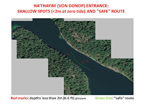
The depth data included 747 soundings... far too many. I decided to reduce the data to (i) depth less than 2m (6.6 feet) as well as (ii) a "safe" route for most boats (unless your boat draws 8 feet!). These data are plotted on a geo-referenced satellite image of the narrows.

As shown below, I converted image to a kap chartfile (which can be read by most charting software, but not onboard dedicated chartplotters), and saved the <2m waypoints and safe route into a GPX file (which CAN be read by most dedicated chartplotters, after conversion, as well as most charting software).  For those wishing to download, see below.


Note the "+" on the CHS chart is a little north of the actual rocks. The blue line indicate the "safe" route (for Pelagia, at least). 

UPDATE (March, 2021): Paul Higgins has updated his excellent SAT2CHART program to now input depths (in the form of a XYZ file). Below is screenshot of a MBTILES (better than kap) file:

MBTILES file with subset of depths added (in metres). Safe route in blue. Yellow depths are <2m

Now, I have to go kick myself for providing information that makes it easier to enter Von Donop and perhaps increasing the summer crowds. Just kidding! (Although VonDonop is indeed very crowded in July/August!) 

Hopefully this detailed information make entry/exit safer for all. For added safety, subtract 0.5m from the depths to account for possible errors in tide-level correction.

Nevertheless, even with this detailed information, we still go very slow by the rock... one never knows what's lurking below.

Stay safe!


CLICK HERE (updated Mar 14, 2021) to download from Google Drive, the zip file containing the above information, including:

  • Detailed description and instructions, as well as caveats
  • geo-referenced satellite image kap file
  • geo-referenced satellite image MBTILES file, WITH DEPTHS (in metres)
  • GPX file containing <2m depth waypoints and "safe" route waypoints

NOTE: Use at your own risk; there are no guarantees these will be safe for you.

Sunday, 9 August 2020

Sailing home... summer cruise completed

Closehauled, sailing past Howe Sound (smoggy Vancouver in the distance)


We ended-up spending another 10 days in the Desolation Sound area. Enjoying sunny, warm/hot weather and good swimming in the ocean (19-24°C). But it was now definitely crowded; perhaps about 2/3 to 3/4 as busy as a normal summer crowd (no USA boats), but still crowded. We enjoyed more socializing with SV Chanter's Wayne and Lee, as well as with Roly from MV Tropic Isle. Still, we decided we'd hung out enough, and it was now time to leave the crowds and get home to Whistler.


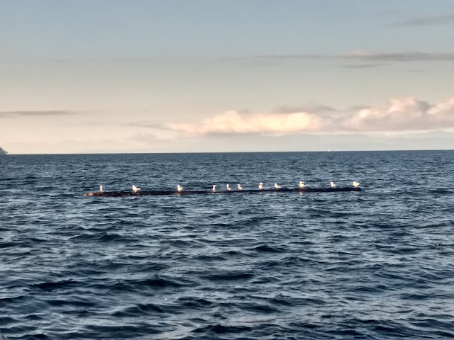
Seagulls physically distancing... (these logs are why we try not to sail in the dark in BC)

We had a long but smooth motor down to Pender Harbour. Normally, we stay at the VRC outstation, but it was full (as we said, places are now crowded). Instead of anchoring in Garden Bay, with its many other anchored boats, we decided to anchor in uncrowded Gerrans Bay. Big mistake! Until darkness came, we were continuously rocked by wakes of boats roaring by, including personal watercraft (non affectionately referred to by some, us included, as "sea lice") roaring around towing people. Pender Harbour is easily the most obnoxious anchorage we've ever been to (although Tofino ranks up there): no one gives a second thought to their wakes. 

We headed home with a 5-15 knot Southeasterly predicted. We hoped we might get a sail home, albeit an upwind closehauled sail. As it turned out, we sailed 21 nm, about half the distance, with the winds mostly SE 12-15 kn, closehauled with a reef in the main. Seas also built, especially when against the tide. Lots of green water over the deck. A fun raucous sail home! 

We arrived to our home berth at the Vancouver Rowing Club in Stanley Park near low tide, with only 1-2 feet under our keel. A tight fit with no space for a wide turn (too shallow, but at least all mud), we were lucky this day and came in slowly with no incident. It was hot at the docks. Later, we had a couple family members over for a fun reunion dinner of barbecued burgers.

Next day, while Michelle packed up Pelagia, David caught the Epic Rides bus up to Whistler to get our car and then drove back down to the boat. We arrived home to (busy!) Whistler by dinner time.

An interesting cruise; 760 nm overall.  Much good (socializing within our bubble with Chanter and Carousel, plus Roly; new anchorages; much wildlife; near-empty anchorages in June and in the Broughtons) but some not so good (very so-so weather with rain in June and early July; windlass motor, etc).


Tuesday, 28 July 2020

Back down to Desolation Sound area...

Huaskin Lake... easily accessed from Turnbull Cove

Weather in the Broughtons improved somewhat (it's all relative... highs were never more than 15°C), so we kept exploring, including Joe Cove (new to us, as was Monday Anchorage), Waddington Bay, Cullen Harbour, and Turnbull Cove. Sadly, our cruising buddies Gillian and David on SV Carousel decided to head back south after Waddington Bay (our social "bubble" burst, decreasing to 4).


Turnbull was new to us. An excellent anchorage (and not crowded this year), its cold water was chocolate brown from nearby streams. But it held a treat: a 10-minute hike uphill brings one to Huaskin Lake, with a convenient dock and ladder for swimming. Surprisingly, the water temperature was quite comfortable for a swim. We also enjoyed socializing with friends Wayne and Lee on SV Chanter (part of our original 6-person social "bubble").


Turnbull Cove was technically the furthest north we would go this year, but we did venture further west to Blunden Harbour. Blunden is a favourite, but this time we got to endure 12 hours of winds, gusting to 27 knots. Fortunately, there was plenty of space and good holding (mud), so we didn't budge. Still, never "fun".


We then headed across to Port McNeill to reprovision, opting to stay 2 nights to be more relaxed. Besides, Port McNeill deserves it, being so welcoming during these COVID-19 times (in contrast with Sointula, which we normally prefer, but we skipped this year as they are not being so "open" to visiting boaters).


After McNeill, we headed back into the Broughtons, staying a night behind Dead Point, which had too many commercial crab traps (far too common an issue in the area) but was nice and quiet (we were solo). Then we rejoined Chanter in Port Harvey, with a plan to head down Johnstone Strait in the early morning.


After our slow trip bucking the flood tide coming up Johnstone 3 weeks earlier, we were worried going in the morning when the ebb was in play would again be a problem. It wasn't. We had a great sail down Johnstone Strait, then Sunderland Channel. We temporarily anchored for lunch (KD time on Pelagia) waiting for Whirlpool Rapids to quiet down, then sailed again up Chancellor Channel, all the way to Greene Point rapids (where we reached 11 knots going with the flood). Altogether, we sailed half the distance. A good day, with our hydrovane Finn doing a great job.


A night anchored in Cordero Islands (and dinner with Chanter), then we headed through the Yaculta Rapids (surprisingly devoid of usual many gin palaces... well, there was one) and down to the Desolation Sound area, to Hathayim/Von Donop Inlet.


Here in Von Donop, the weather has been hot (30°C) and the water warm (20°C) for swimming. Although far busier than the Broughtons (or Von Donop last month) , the 34 boats total on  our first night back are far less than the usual 50-60 boats of normal years. (Indeed, yesterday and today, the numbers have dropped to 15-20 boats.)


We expect to be home no later than August 7-10th. Until then? Plans are flexible.

Saturday, 11 July 2020

To the Broughtons...


SVs Carousel, Pelagia and Chanter anchored in Monday Anchorage


After nearly a month in the Desolation Sound/Discovery Islands area, it was time to move on.

Our time in Desolation Sound started with nearly empty anchorages combined with only "warmish" air and (sea) water temperatures (too cold for us to swim). By the end, seas had warmed up so that we were enjoying swimming, there were some sunny days, and the anchorages definitely becoming busy. Not the pre-Covid-19 stupid-busy with 60-80 boats (and often majority American boats), but busy such that we'd see 15-20 (Canadian) boats. Call it "Canadian busy".

So it was time to move on.

We headed to the Broughtons, with hope of empty anchorages, mild bucolic days, and wildlife. We got some of this, including many black bear sightings, a close-up in our kayaks with a wading grizzly bear, and many whale sightings.

Getting to the Broughtons, however, included a real slog bucking the tide in Johnstone Strait (wasn't supposed to be a flood with 5+ knots against us!) that happily ended with a great 9-mile sail (steered by Finn, our windvane).

The weather for the first week in the Broughtons was better than forecasted, allowing for many kayak trips. But never that warm. The past few days, unfortunately, have been soaked with torrential rains and some wind. And the coming week has rainfall predicted every day.
Making us consider returning south (well, actually east) back down Johnstone to Desolation and perhaps home.

But first, we are giving it another try in the northern Broughtons. Currently, we are anchored in "Monday Anchorage" (don't be fooled by its name: Monday is not a good anchorage in windy weather), waiting/hoping for the rain to let up.

We shall see....


Update: the rain did indeed end, in time for drinks in the cockpit before dinner.

Monday, 29 June 2020

Windlass woes (and eventual win)

Windlass motor with broken "up" stub (circled)


June 16, 2020:

Can't always be fun and games.... 

Windlass problems occur every once in a while (in case you are wondering, the windlass is the equipment we use to raise/lower the anchor). But our problem turned out to be terminal: our positive "up" terminal had sheared off, and this meant the end for the motor. 

Of course, it happened when we had a lot of chain out (230'). Fortunately, back in 2008, we purchased a "manual recovery kit" for the windlass. Unfortunately, it was very hard work for David to bring it all up. Nearing the end, he was sweating hard and taking multiple breather breaks. But up it came. 

We headed to the docks of Refuge Cove, where David removed the motor/gearbox assembly. It did not look good (as we said, it was "terminal"). At least it was easy to remove. 

Next morning, we started making calls. First call was to Ocean Pacific Marine in Campbell River. Using our part number, they said it looked like it would have to be ordered from England. Yikes! We started planning a fast return to our docks in Vancouver. But, 20 minutes later, they us called back, saying there was a new part number and indeed, there was a replacement in Victoria. It was Friday morning and they should be able to get it to Campbell River by Monday "11ish".

Only $2300.... 

After a couple of nights at the dock at Refuge Cove (where we sorted out our backup - - and much lighter -- anchor line), we headed over to Gowlland Harbour (very near Campbell River) to try anchoring without a windlass for a couple of nights. Turned out to be a great anchorage (tons of room with only 1 other boat). Later, using a winch on the mast, we had no problem getting our anchor (with lighter line) up. 

Monday morning, we headed over to the Discovery Marina in Campbell River, where Ocean Pacific Marine was conveniently located. By 1130am, the new windlass motor assembly had arrived. After some concern it was the wrong part (it may have been mislabled... but phone calls to distributor indicated it would only fit properly if it were correct), David installed it (in between torrents of rain). And it worked! 

Next morning, we headed back over to Cortes Island, to Hathayim/Von Donop Marine Park, a favourite of ours. 

A pricey part, but still a "win" since we could do our own repairs, and get back  cruising. 

Wednesday, 17 June 2020

Desolation Sound 2020: Canadian boats only!

Laura Cove in mid-June: Amazingly empty!


Desolation Sound in the summer is normally a very crowded affair. It is not uncommon to find 50-80 boats in each anchorage. For us, some anchorages are simply "no go" places in the Summer, such as Prideaux Haven (many large motor yachts -- "gin palaces" -- among 50-80 other boats) or Laura Cove (stern-tied boats packed together like sardines). 

Typically, 70-80% of the boats in Desolation in the Summer are boats from the USA. Like many Canadian boaters, we admit too often being upset to have so many American boats taking up most of the anchor spaces, leaving little space for us, and certainly no feeling of "wilderness" or privacy. We have often wished there was some way to limit the number of American boats in order to give some priority, some access, to local boats. (Don't get me wrong: there is nothing inherently wrong with our neighbours visiting from the south, it is just that there are SO MANY of them!) 

Well, it turns out there is a way...

Unfortunately, it took a pandemic to clear out the anchorages. Especially with the COVID-19 pandemic so out-of-control in many USA states, the Canada-USA border has been closed to non-essential travel (since early April) and will stay closed until at least July 21st (after which the closure could again be extended). 

We've spent the past 2 weeks enjoying our cruising of the Desolation Sound area. Anchorages have been remarkably quiet and empty: perhaps about 10% of the usual number of boats. (For example, here in Von Donop Inlet, there are currently only 5 boats, when normally, in mid-late June, there would be 30+ boats.) There are also fewer Canadian boats than usual, but these are now starting to increase in numbers as restrictions in BC ease. 1

We are spending extra time here in Desolation Sound, as it not likely we'll ever get to see Desolation so uncrowded (in the summer) again. I'm sorry for the American boaters wishing to come north to experience our wilderness (we are in regular communication on HAM radio with some American boaters, regular summer visitors to B.C. waters, who seem shocked and very unhappy to be excluded from Canadian waters, as if somehow we have trampled on their "rights"). 

These are remarkable times, and the differences between our two countries have never been more evident. It might not be until the Fall (or even next year), but hopefully the situation south (and  north) of the USA-Canada border will significantly improve, and the border will reopen and we will once again welcome our southern neighbours. 

Until then, we will enjoy our uncrowded B.C. waters with other fellow Canadian boaters. 


1. We hear that anchorages down in Washington State are also/currently very uncrowded, so it's a good time for Washington boaters to explore their home waters. 

Wednesday, 27 May 2020

Off for a summer (?) cruise... despite COVID-19

Heading towards Texada Island/Welcome Passage

After weeks of deliberation and occasional disagreement, we have left Whistler and Vancouver for a 1-3-month cruise North/West. 

British Columbia had seriously "flattened the curve" and business and provincial parks are opening up, especially June 1st. An interesting change is that only BC residents are allowed to camp in BC Parks this Summer (David is not 100% in favour of this idea; they should be open to other Canadians... and vice versa), and USA-Americans cannot cross the border for non-essential purposes until at least June 21.That means 60-70% fewer boats in Desolation Sound. Finally we can visit in high season and not fight for space in our own province! 

We had originally planned to go to Haida Gwaii (for a 4th time), but that is very very unlikely as the Haida are currently not welcoming visitors. Indeed, how far we do go will depend a lot on whether communities start to welcome boaters. We shall see... certainly Desolation Sound. 

In the meantime, we have fully provisioned Pelagia, so no need to shop in small communities.    

Stocked up for the trip

Currently at the Vancouver Rowing Club outstation in Pender Harbour, where the resort has been very welcoming. 

Motoring past Howe Sound, Mt. Garibaldi in the distance (Whistler is past Mt. Garibaldi)


Saturday, 11 April 2020

Physical distancing during COVID-19: A Canadian view...


from Wild Wise Sooke (https://www.wildwisesooke.com/)


We are going for daily walks here in Whistler, often around the Whistler Golf Course.

In the past week, we've seen two three black bears (one two on the golf course and one that crossed our path right in front of us). In these cases, we are maintaining much more than the 2m distance required between humans...!


Bear grazing on the golf course (April 12, 2020)

Tuesday, 24 March 2020

COVID-19: Whistler, British Columbia & Canada shutdown...

Illustration for The Tyee by Christopher Cheung. The Scream via Wikipedia, public domain; mask image via Wikipedia, public domain. https://thetyee.ca/News/2020/03/27/Coronavirus-Curated-Top-Links-March-27/

March 15th: Vail Resorts shuts down all of its ski resorts in North America, including Whistler-Blackcomb. (Within a few days afterwards, pretty well all ski areas in B.C. also shutdown.)

A sudden, surprising end to the ski season.

But that's nothing compared to what's happening across Canada and around the world, as the COVID-19 pandemic spreads.

Borders are closed (including all "non-essential" travel across the USA-Canada border). We, like almost all Canadians, are keeping our distance from others (physical distancing), going out only for required food (and liquor 😉) shopping, as well as walks (on the now-quiet Valley Trail) for fresh air and exercise.

(Well, David has driven down to the boat a couple of times; but still keeping isolated.)

Our plans to sail North on Pelagia this Summer would seem an excellent way to self-isolate (even our doctor thinks so), but...

Communities up-and-down the B.C. coast are circling-the-wagons and telling non-residents to stay away. Anchoring in coves away from communities should be fine, but we do have to re-provision, get water (though there are streams) and fuel up.

So, plans this Spring-Summer are truly "written in the sand at low tide". Still some time to go. We shall see.

Until then, we are trying to stay healthy, and wish the same for all others!


Empty Whistler (https://www.wayneflannavalancheblog.com/)

Sunday, 16 February 2020

The skiing is good... despite Vail Resorts (owners of Whistler-Blackcomb ski area)

Whistler peak, February 12, 2020

Mid February and the skiing is good.

LOTS of snow fell in January (after almost none November & December).

Weekends (especially holiday weekends such as this weekend) are quite crowded -- welcome to Whistler -- and Vail Resorts (owners of Whistler-Blackcomb) are not making a lot of friends with "locals" (Whistler, Sea-to-Sky area, Vancouver)! A current change.org petition, with nearly 9000 signers (to date), shows how upset people are.

Vail tries to suggest this is all due to the poor start of the season snow-wise (it was terrible until the first days of January, with little snow, little open and huge Christmas crowds), but those who live here know that's not the reasons people are so unhappy with Vail Resorts. Checkout the comments in the petition to see the many reasons.

We live here, so we make the best of it (such as staying away from the hill on a holiday weekend!)....

And it's so much better than living in the city!