|
| Solar panels! |
Part I: New additions that we found to be essential
UNDER CONSTRUCTION:
As boaters prepare their boats to cruise to/in Mexico, we felt we should highlight a few additions we made to Pelagia that we found particularly helpful and, indeed, essential. (This list does not consider gear already/normally on Pelagia, such as the sails, engine, autopilot, chartplotter, radar, etc.)
Readers might also be interested in our other blog posts concerning Mexican charts, weather and communications:
http://sailing-pelagia.blogspot.ca/2014/07/information-for-cruising-mexico-charts.html
http://sailing-pelagia.blogspot.ca/2015/05/mexico-nautical-charts-c-map-and.html
Listed below are some items we feel were "essential" to our successful, safe, and (mostly) comfortable cruising to/in Mexico. The list is not complete (see also future blog posts considering "Less useful" and "nice to have but not essential" items). These lists reflect our personal views -- others might not agree.
"Detailed" notes can be found at the bottom of this post.
 |
| 4 solar panels over bimini |
Solar panels/charge controller:
We added four 90W panels to the top of our bimini (and a
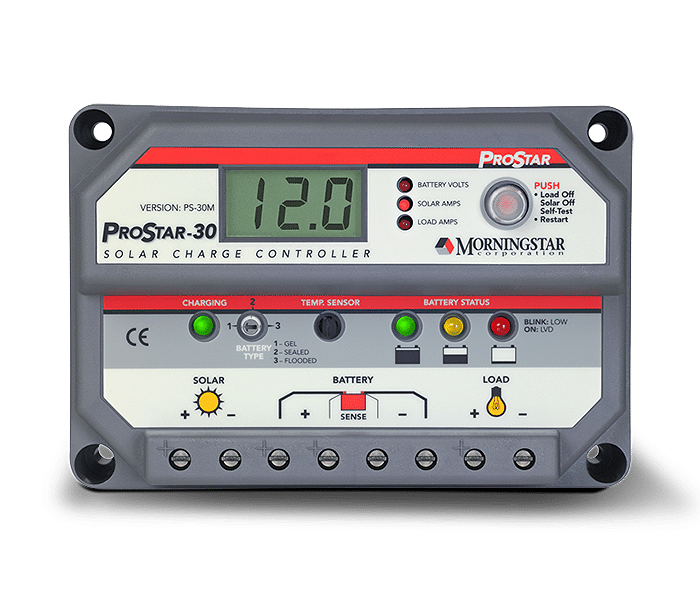
Morningstar Pro-Star 30-amp PWN solar charge controller [
1] installed in a cockpit locker) only a week or so before leaving.
This addition changed our cruising life (while at anchor or sailing) -- effectively removing all worries about our battery charging while in Mexico [
2].
With so much sun in Mexico, it was common for this system to provide
13-16 amps/hr charging in the midday, and 5-6 amps/hr on cloudier days [
3]. We had little worry even with our air-cooled Nova-Kool refrigerator running 24 hrs/day.
Marine SSB/HAM radio with Pactor 4 modem, airmail software, and Sailmail membership:
This system [4] was critical to us for obtaining marine weather information in Mexico, as well as the Neah Bay-to-San Francisco offshore section [5].
We wrote about weather forecasting in a previous post. There is no official marine weather forecasting (that we could find) in Pacific Mexico; no forecasts are available the VHF radio [6]. The only forecasts available, all unofficial or experimental, must be obtained in one or more of the following ways: (i) downloaded from the internet, or (ii) audio (i.e., listened to) on Marine SSB/HAM radio [7].
Audio forecasts are primarily: (i) Geary's excellent (but, nevertheless, amateur) daily forecast delivered on the SONRISA HAM SSB Net each morning, and (ii) Stan's computer-generated (no human input) forecasts read out on the AMIGO Marine SSB net each morning. (These forecasts, plus extra information, are easily downloaded from the internet or by using low-bandwidth email such as SSB/HAM-based or Satellite Phone-based airmail/sailmail and SailDocs.)
Not to be underestimated, additional real-time on-the-spot weather information is obtained by listening to boaters when they check-in on the SONRISA and AMIGO nets; moreover, individuals may, and often do, request "weather fills" (additional details for specific areas) from Geary; this audio information is not available on the internet or by using a satellite phone.
Forecasts on the Internet: in addition to Geary's and Stan's forecasts, experimental NOAA forecasts, and other forecasts are available as text files (most easily using Saildocs). GRIB files are also easily available to download (these files are computer-generated "forecasts" in graphic form which have no human input and thus do not take multiple factors into account such as local conditions, topography etc). While at sea or at anchor (and away from broadband or cell-phone based internet), these files can be downloaded using a satellite phone with a data plan or, as we did, using our Marine SSB, Pactor modem, and Airmail software (and Sailmail membership)[8]. Another great feature of Marine and HAM SSB radios is the ability to talk to other boaters located up-and-down the coast (or on a passage), and to learn the locations of others, often friends, by listening to the SONRISA and AMIGO nets, or other nets such as the Pacific Seafarer's Net (difficult or not possible using a satellite phone).[9]
Shawn & Heather's (Blue Latitude Press) Guidebooks and Waypoints:
 As we noted in our earlier post, the Blue Latitude Press guidebooks are excellent and essential [Sea of Cortez: A Cruiser's Guidebook. 3rd Ed.; Pacific Mexico: A Cruiser's Guidebook].
Additionally, we downloaded digital/electronic versions of all their waypoints [10] so that they could be easily transferred to our Furuno chartplotter as well as to a computer-based charting program (OpenCPN) [11]. The guidebooks provide large-scale detailed chartlets [12], with the locations of these waypoints accurately indicated. (These chartlets are also available as electronic charts -- see Note #12.) Given the lack of accurate and detailed marine charts for most areas of the Mexican coast, Shawn and Heather's accurate waypoints gave us confidence in navigating closer to shore and when anchoring. Download the waypoints, and don't leave San Diego without purchasing these excellent guidebooks [13
].
(Bulk) Water Treatment System:
Before coming to Mexico, have a method to treat water obtained from marina and fuel dock taps. We recommend obtaining a Filter/UV Sterilization system.
Most cruisers reading this heading will immediately think "watermaker", but this is not what we are referring
to. Due to pollution (especially the slightest bit of gas, diesel, or oil), watermakers are rarely useful in marinas, as well as in some crowded anchorages where there may be poor water circulation and/or pollution (e.g., Barra de Navidad lagoon).
We stayed in marinas a lot (especially Marina Palmira, La Paz). A watermaker, if we had one (we don't), would be useless here [14]. Many cruisers purchase water for their tanks; at about C$2.50-$3.00 per 19-litre garrafone arranged through a marina (a little less if you do not need to tip staff from the water company, or deal directly with agua purificada store), filling our tanks (~460 litres or 24 bottles) can really add up (C$60/fill!). Additionally, lugging these large heavy bottles to the boat and the subsequent pouring into the tank fills are a pain. Finally, in many places it can be difficult to find more than a few bottles at a time. We usually used dock water, filtering and chemically treating the water.

Rather than purchasing water in bottles, some cruisers treat the water at their dock taps using combinations of filters, UV sterilization, and/or chemical treatment.
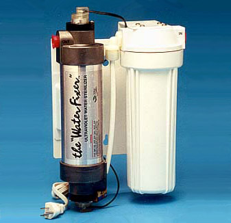
Waterfixer makes Filter/UV sterilization systems (available directly from manufacturer, or through
Downwind Marine in San Diego). Tom at
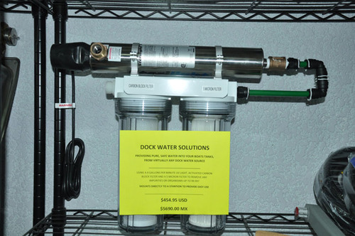
La Paz Cruiser's Supply also sells a filter/UV Sterilization system. One hooks the water hose up to the filter/UV system, applies power (12v or 110v, depending on version purchased), run it a bit to clear filters, then take its output to the boat's water tank(s). The system is portable and can be temporarily hung on the lifelines while filling.
In our case, we first filtered the dock water as we put it into our tanks, then chemically treated each tank (using a solution similar to Microdyn, but a much less expensive Soriana/City club store brand). This system worked well for us [15]. A better system, however, is a combination filter/UV sterilization system, such as noted above.
Fans to cool you off in hot weather:
It gets really hot on the boat in Mexico! Short of an air conditioner (which we certainly did not have), the primary way of cooling off inside was by using fans (in addition to open hatches and windscoops). Before leaving Vancouver, we installed two fans in the V-berth, two fans in the main salon, and one fan in the galley. All of these fans were
Caframo "Bora" 3-speed fans, which were fairly powerful (for their size), (relatively) quiet, and very easy on the batteries.
Be sure to bring multiple spares of your fans: when we returned to Mexico after leaving Pelagia in Mazatlan for the Summer, we found the 3-speed switches on two fans were stuck in one position (rather suspiciously, the two broken fans were next to windows that had been replaced over the Summer -- we
believe their problems stemmed from damage occurring when the windows were removed and/or replaced). Fortunately, we had one spare Bora, plus a used spare Hella 2-speed "Turbo" fan to replace the damaged Boras. The Hella Turbo is noisier than the Caframo Bora, and has no protective grid at its back, making it awkward to adjust the fan when it is running. We prefer the Boras.
Bug screens for windows/hatches and companionway:
Whether it is the pesky little mosquitoes whose "bite" carries a real itchy punch (and, possibly, Dengue fever), nasty "
jejenes" ("hey-hey-nes", no-seeums) which are tiny and give a rash of itchy sores, or bees searching for fresh water, you need a good bug screen setup for your boat.
Our new Lewmar portlights came with somewhat flimsy but effective bug screens; for the hatches and the companionway, we purchased "
Sogeman Bugbuster" screens, which worked very well. These are available direct from Sogeman, as well from many online marine businesses in Canada and the USA.
A real downside to bug screens is that they really cut down on air flow -- a real problem when the temperatures heat up!
Other essential items (we already had on Pelagia)
(i.e, not installed specifically for Mexico)
- 25-kg ROCNA anchor and 300' all-chain rode, with Lewmar V2 windlass [16]
- Furuno 1724C Radar/Chartplotter (with annually-updated C-Map card)
- Wagner S50 Autopilot. Old technology (not computer compatible...), but a workhorse that always kept true
- OpenCPN PC-based charting system with official USA and Canada RASTER charts, CM93 worldwide VECTOR charts, and GE2KAP/Google Earth software (for preparing GPS-accurate Google Earth "charts")
- Nova Kool LT201-RT6 air-cooled refrigerator in ice box with 3-inch insulation [17] Kept items cold; froze meats and kept them frozen; and made ice (using only the RT6 ice box as a freezer). As noted above, our solar charging system had no problem keeping up (and surpassing) the energy demands of this 2.2 amp/hr Nova Kool system.
Detailed notes:
Solar panels/charge controller:
[
1]
We had planned to obtain a
MPPT controller. However, the solar power specialist from whom we
purchased the panels and controller strongly recommended a PWN over the
MPPT controllers. When we objected ("but online blogs and 'experts' say
we must get a MPPT controller...!"), he went so far as to telephone a
Morningstar representative, who also agreed with his advice: we would be
paying extra money for a MPPT controller but receive no benefit due to
the small size of our solar array. For those concerned with electrical
noise from the PWN controller during SSB/HAM radio use, we found such
noise was only an issue when the PWN controller went into Stage 3
charging; it was simple to turn off the controller when required.
[
2]
The
only time we had concerns with charging and battery levels was on the
3rd day of our Ensenada-to-Turtle Bay passage; all three days (and 2
nights) were cloudy and the combination of sailing, lower panel output,
and (too much) use of the autopilot resulted in lower battery levels.
Our first day in Turtle Bay, it rained solid for most of the day. This
was the one and only time we felt we needed to use our Honda generator.
[3] Back
home in British Columbia, we still seem to be getting 12-15 amps/hr
charging late morning until early afternoon on sunny days, and 4-8 amps/hr at other times
(and 4-8 amps/hr on days with high clouds).
Marine SSB/HAM radio with Pactor 4 modem, airmail software, and Sailmail membership:
[4] Our
Marine/Ham SSB radio is the ICOM M802. This radio can be set to
receive/transmit on all Marine and Amateur Radio (HAM) frequencies in
the "high frequency" range (i.e., up to 30 MHz), and works very well for
us. (However, there are other HAM radios with fewer "bells and
whistles" (which we also did not use) available at a lower price.)
Rather than the more-complicated ground-plane installation, we used the "KISS Ground Plane" (actually, a counterpoise) -- a very easy installation that worked very well for us (as well as friends on other boats), despite the "kerfuffle" sometimes associated with it.
[5] At
times we were over 100 nm off the coast of
Washington/Oregon/California, making reception of NOAA weather forecasts
on VHF radio sometimes difficult (though, surprisingly, we were often
able to receive VHF forecasts this far off the coast). However, even
when we could hear forecasts on VHF, we still relied on the text
forecasts downloaded using our SSB radio/Pactor modem. NOAA VHF
forecasts would usually cover a small area, so it was hard to "look
ahead", and equally important, the huge number of forecast regions off
the West coast was very confusing, and having these forecasts downloaded
and saved in text format made it easier to interpret. (We had very "difficult" weather -- gales and "hazardous seas" -- off of the Oregon/Northern California and we should have been better at evaluating the many NOAA forecasts....)
[6] In
several locations popular with cruisers (La Paz, Puerto Escondido,
Mazatlan, Banderas Bay, etc), there are "cruisers' nets most mornings on
VHF radio, when weather forecasts are read aloud (usually either Geary's
or Stan's). These forecasts on VHF nets are not obtainable when one is
farther away or when land mass intervenes. Also, in some harbours (e.g.,
Puerto San Carlos in Bahia Magdalena), the Port Captain reads aloud (in
Spanish) a daily weather forecast on VHF radio.
[7] Weather
forecasts on Marine SSB and HAM SSB may be listened to by anyone, even
those without a Marine ROC or an Amateur Radio (HAM) certificate
(provided their radio can tune to these frequencies). Technically, a marine ROC
("restricted operators certificate") and station license (outside of USA/Canada) are required to transmit on marine
frequencies (VHF and high-frequency marine SSB). A HAM certificate is
required to transmit on HAM frequencies. However, in the case of a true emergency, HAM and Marine NETS will take
calls from anyone.
[8] Email access to HAM stations is free to HAMs using Winlink2000.
Access to Marine SSB Sailmail requires a US$250/yr membership (and a
marine "station license"). In Mexico, we found connections to HAM
stations to be difficult, slow and often unobtainable. Sailmail
stations, on the other hand, were easy to connect to and much faster
than the HAM stations. (This situation continues for us in British
Columbia.)
[9]
In the case of an emergency, a broadcast on marine and HAM SSB
frequencies and associated NETS will be heard by boats nearby and far --
as well as by land stations -- possibly enabling faster assistance. A
satellite phone cannot do this.
Shawn & Heather's (Blue Latitude Press) Guidebooks and Waypoints:
[10] One
could, as many do, enter each waypoint manually. However, errors can
occur doing it this way, and it is a lot work. The ease of downloading
and transferring waypoints accurately makes the low cost of downloading
these waypoints (US$4.95 per guidebook) an excellent investment.
[11] We use GPSUtility to modify and transfer waypoints to our chartplotter (and other GPS systems).
[12] The detailed chartlets in the Blue Latitude Press guides are now available
as GPS-accurate electronic charts for PC, Android, IPad and Mac. The charts are the
same price for all platforms; however, software required to view these
charts is expensive for PC and Mac, but quite reasonably priced for
Android ("PathAway" charting software) and IPad ("INavX" charting software) tablets. See Blue Latitude Press
and Fugawi X-Traverse
websites. We only recently learned about these electronic charts, thus
we did not have this while in Mexico. If we were returning to Mexico, we would definitely have these on
our Android.
[
13]
Unfortunately, Blue Latitude Press guides do not
cover the Pacific Coast of the Baja peninsula. Most of these areas do
not have official large-scale detailed charts (electronic charts such as C-Map and Navionics reflect this lack of detailed charting), and the existing cruising
guides, in our mind, are lacking in accurate details (especially, no
GPS-accurate chartlets). In a subsequent post, we will suggest using OpenCPN charting software and GPS-accurate "charts" (Google Earth photos) produced using GE2KAP software to provide additional information for sailing down the outside of Baja (and, indeed, for anchorages elsewhere in Mexico).
(Bulk) Water Treatment System:
[14] We do not have a watermaker. Given Pelagia's large water tanks -- and we plan to install a third water tank, replacing a 30-gallon diesel tank we removed two years ago -- and how much we stayed in marinas, we did not need one while in Mexico. Decent watermakers (e.g., Spectra) are very expensive, both in initial purchase (US$5000-$15,000), installation, and in ongoing maintenance. They require substantial energy to produce water, and usually take up a lot of space. Moreover, watermakers are easily among the most common items to fail during cruising (along with autopilots and refrigerators). So, a watermaker is still not on our "wish" list for Pelagia (although, given current drought conditions in southern BC, especially on the islands, one has to wonder...).
[15] In two seasons of cruising in Mexico, we had food/water-borne sickness only once: Giardia. We have no way of knowing where we picked this up (it takes 8-10 days for symptoms to show up, and they are not that obvious); likely it was from eating out (cruiser friends in La Paz were also hit by Giardia, at a different time, even though they only used bottled water in their tanks). Happily, Giardia is pretty easy to treat using Tinidazole (Fasigyn in Mexico) -- and we are pretty familiar with it from our many trips to Nepal. As for tank treatment: one could use chlorine (i.e., bleach) to disinfect water after filtering (the filtering is required to remove sediments and cysts/parasites such as Giardia and Cryptosporidium). However, using chlorine to disinfect is not recommended for our aluminum water tanks.
Other items:
[16] We
never used more than 200' while in the Sea of Cortez (the remaining
100' is lower down in a 2nd chain locker below the V-berth. One never
knows when one needs the extra chain (think Hurricanes...).
[
17]
We purchased a new Nova Kool conversion system in 2013 -- similar to our existing and functioning 10-15-year-old Nova Kool system (that we had been told, in 2010, was on its last legs) -- stored it on Pelagia and carried it all the way to La Paz. This new system was supposed to be more efficient -- using only 2.2 amps/hour. We had Will at Techs Mex in La Paz install the new Nova Kool (the old Nova Kool was donated to a family in San Evaristo, where it was installed in conjunction with a large ice chest; with a charge of refrigerant, we are told it works great. So much for being on its "last legs".) Other cruisers had more-expensive "fancier" systems. We were worried our comparatively simple (and less-expensive) air-cooled Nova Kool couldn't compete. To the contrary, it worked great and gave us no problems.