Wednesday, 1 December 2021

Another ski season begins (2021-2022)... will COVID shut Whistler down early again?

Opening day on Blackcomb Mountain 2021
 

The 2021-2022 ski season has started here in Whistler. Lots of snow for the first few days giving hope it will be a good one.

However, Vail Resorts/Whistler-Blackcomb is refusing to listen to the wishes of most Whistler residents, who have made it loud and clear that they want Vail/W-B to require proof of vaccination to ride its gondolas (see petition, below). The B.C. Provincial Health Officer requires proof of vaccination to enter bars and restaurants (and much else), but she doesn't seem to comprehend that ski gondolas are tiny enclosed places with only inches between passengers (there are 6-10 people crammed into each gondola, often with windows frozen shut, for a 20-25-minute ride). So, without a vaccine mandate from the Government, Vail/W-B is balking.

Nearly 12,000 people have thus far signed a petition asking for this vaccine mandate. Thus far, W-B/Vail continues to demonstrate it doesn't care about Whistler residents and others' safety.

So who knows about this new ski season. It too may be shut down early (in March) as has been for the past two seasons (skiing normally goes to the end of May). Another shutdown will be devastating for local businesses (and us skiers/riders)!

On the weather front: Yet another "atmospheric river" is hitting us. Been raining here top to bottom -- all that snow has disappeared halfway up the mountain.

Sigh....

Thursday, 16 September 2021

A Fall visit to the Gulf Islands (2021)

Sunset in Glenthorne Passage
September, 2021: 

A week or so planned in the Gulf Islands, hoping to meet up with cruising friends (SV Carousel and Chanter), as well as to visit family.

Day 1: Vancouver to Dogfish Bay (Kendrick Island): A good sail 75% across Georgia Strait (not too slow but not too crazy). First boat in anchorage (2-3 others arrived later). 

Day 2: A nice quiet night at anchor. Headed through Gabriola Passage near slack, and motored (calm, sunny) down to Montague Harbour, with idea of meeting others. Lots of available buoys -- didn't stop one boat from anchoring within the buoys, all to save a few bucks -- Montague was far too busy! We contacted others, and arranged to meet elsewhere next day.

Day 3: A quiet night on the buoy at Montague. Headed down to Irish Bay. Sunny and calm. We went for a kayak to Winter Cove (including out and back through Boat Passage) and met up with SV Carousel (Gillian and David), as well as SV Fanuei (David & Janet). We haven't seen Fanuei folks since 2007, when we met them up on the North Coast (we were on Dancer, our Landfall 38) . They were quite surprised when they realized who we were. (We've been on HAM radio for years as D&M from Pelagia... they never put 2 & 2 together.) The three boats had a fun meal together in Irish Bay.

Day 4: With Carousel, we head to narrow, shallow Annette Inlet (Prevost Island), while Fanuei heads elsewhere.  Drizzly rain, we get a short sail in, but mostly motoring. Quiet, drizzly, foggy evening, with dinner aboard Pelagia with Carousel.

Day 5: No wind, but also no rain. We head to Sidney Spit while Carousel heads to home port. Lots of buoys available at the spit, but not a lot with good depth (given near-zero low tide). Went for a nice walk.

Day 6: Quiet eve. We head over to Port Sidney marina, where we have a reservation and plans to go out with family. Got a little grocery shopping in, but we're not fans of Sidney -- far too "touristy". Unfortunately, only got to have dinner with 2 of our family, the others being nervous due to COVID worries. (All understandable, just wish we'd been told this before making marina reservation.) Still, had a enjoyable dinner with those feeling comfortable to meet up. 

Day 7: Escaped Port Sidney, and headed over to Glenthorne Passage (Prevost Island). Plan was to meet here with Lee and Wayne on SV Chanter the next morning. A few other boats, but not crowded. Beautiful sunset (photo),

Day 8: A quiet eve. In the morning, got message from Lee and Wayne that their grandson (who had just been staying with them) was sick, and off for a COVID test. Damn! Being cautious, we all agreed it best to cancel our get-together. We weighed anchor and headed up Trincomali Channel (against a NW wind) to Clam Bay, to set us up for Porlier Pass and Georgia Strait the next morning. The forecast for Georgia Strait was decent the next day, but later in the evening was forecast to change to gale force winds and heavy rain for a couple days. So perhaps it was fortuitous that we had to cancel plans with Chanter.

Of course, not long after we got the anchor down Clam Bay, we got word from Wayne and Lee that the COVID test came back negative and they were off to Glenthorne Passage (they keep Chanter not far away on North Pender Island). We were happy for them and grandson.

The afternoon in Clam Bay was very bouncy with the strong NW winds. Fortunately, winds quieted down by dinner, and it was a quiet eve.

Day 9: Woke up early for ~7am slack at Porlier Pass. Once through Porlier, we raised sails and had a nice, comfortable sail most of the way across (started the motor off the North Fraser Jetty). Put Pelagia to bed at the VRC, and made it home to Whistler for dinner. The strong winds and rain indeed came later that eve.

A nice Fall cruise, with COVID running interference.

Thursday, 12 August 2021

Final days in busy Desolation Sound, then back to home berth

Warm Wednesday Lake (Malaspina Peninsula)

Hot and sunny with warm swimming and crowded anchorages; that's the Desolation Sound area in July and August. 

Surprising the anchorages are so crowded, given the lack of USA boats. So many Canadians have been hitting the waters, not all knowing what they are doing. With the ending of border restrictions, it is hard to contemplate just how crowded it will be next Summer (2022)! 

We enjoyed the swimming and the sunny weather, but became tired of the crowds. We especially became sick of those inconsiderate boaters who roared by with large wakes, made noise at night, and had no clue how to anchor. Although small in total numbers, their negative effect was way beyond their numbers.  

We did find a new-to-us anchorage in the Malaspina Inlet area, which we enjoyed so much we stayed 4 nights. It seemed like a newborn nursery, with many mother seals and their pups, and an eagles nest with eaglets. Small anchorage thus only a few (3-4) boats, with nearby hiking. Best not to advertise its location....

Eventually, we decided it was time to head home. An easy decision made after nights in Cortes Bay with RVYC boats continually roaring by (some far too close) with no concern for those anchored, and an especially obnoxious powerboater (definitely not RVYC) blasting his music late at night. As we left Cortes Bay, we motored slowly past him and told him we didn't appreciate his late-night music tastes, and that loud music late at night was not very considerate of others. He gave us the finger....   [Although we haven't done so, we often wonder if such boats should be named, perhaps on some "Boaters' Wall of Shame" website....] Yes, time for us to head home.

Managed a little downwind sailing down Malaspina Strait, and spent 2 nights in Ballet Bay. Surprised at how busy even Ballet Bay has now become; due to poor charting of Ballet Bay and especially its entry, most boaters in the past seemed to go to nearby Hardy Island Marine Park (formerly Musket Island MP). Now both are busy. Still, we had some nice kayaking and swimming in the area.

Heading down, we again managed some downwind sailing once past Merry Island, but it was frustrating as the seas in Georgia Strait were large and confused. Eventually, the seas overwhelmed the light winds, and we started the motor. We headed into Plumper Cove Marine Park for our last night, pleased to find several buoys available. Unfortunately, it was a noisy place, with Pelagia rolling to constant boat wakes until dark, and continuing to roll overnight due to swells from the strong NW winds out in the Strait. Should have gone on to Artaban. Next time....

Left early to get to our VRC berth with a high-enough tide. Very rolly, confused seas from Point Atkinson almost to First Narrows -- made worse by an ebbing tide against incoming swells. Made it  difficult to see the many logs, and we managed to hit one just before the bridge. It rolled along the hull, down the keel, then popped out behind us, thankfully missing the propeller and rudder.  Loud noises but, fortunately, no damage (David dived on keel to check when back in our VRC berth).

All-in-all, an excellent 2-month cruise. The Broughtons were great (especially near Cape Caution); cruising with friends on SVs Carousel and Chanter a joy. Desolation crowded but relaxing (well, mostly). A little disappointing that we didn't go above Cape Caution (due to Covid-19 restrictions by central coast First Nations), but not enough to take away from the good cruising. But, next year....


Summer 2021 numbers:
Total distance cruised: 746 nm
Engine hours:  130 hrs
Distance sailed: 66 nm


Wednesday, 28 July 2021

4 weeks in the Broughtons; back to Desolation

Pelagia in Miles Inlet

Four weeks total up in the Broughtons/North Vancouver Island/Cape Caution. Lots of good weather (comfortable 15-21°C highs), with a sprinkling of fog and a few showers.


We seemed to enjoy the area more than usual, especially in anchorages at Miles Inlet and Murray Labrynth -- where we met up with SV Chanter -- both near Cape Caution. Lots of kayaking.

Outlet from Miles Inlet Lagoon


Chanter (left) & Pelagia (centre) in Murray Labrynth
 

We went back-and-forth whether to go North of Caution. The main deciding factor was the area, largely part of Heiltsuk traditional territory, was "closed" by the Heiltsuk Nation until July 23rd (and with that, all BC Parks and Conservancies were officially closed, meaning no going ashore). We decided the 23rd was too late. Next year. For sure....

Enjoyable visits with friends on SV Chanter. Also, a dinner with Mexico cruising friends Betty-Ann and Dave.

Many, many sightings of whales, dolphins and porpoises. Oddly,  no bear sightings. And a remarkable encounter with a newborn seal who thought Pelagia then one of our kayaks was its mother. (We left it alone and eventually its mother showed up.)

We returned twice to Sointula, back to its welcoming, relaxed reputation.

Our trip back down South (actually, SE) was highlighted by a great sail down Johnstone Strait, from Havannah Channel to Wellbore Channel (where we anchored in Douglas Bay/Forward Harbour).

We are now back in Desolation, enjoying the sun and ocean swimming.

Saturday, 10 July 2021

HOT, sunny days in Roscoe Bay, then up to the Broughtons

Kayaking in Indian Channel (Broughtons)
 

Three days and nights in Roscoe Bay, with temperatures above 30°C -- the result of the "heat dome". Fortunately, we could jump in the water to cool off (sea water 20°-22°C).

Decided it was time to "head North", up to the Broughtons, where we could catch up with sailing friends on SV Carousel and SV Chanter. After a night in Owen Bay, we headed into Johnston Strait. Although we didn't have winds to sail, we always had a great ebb current helping us along -- sometimes as much as an extra 5 knots! It was an easy, quick trip to Port Harvey. (We were lucky, because 1-2 days later, the gales in Johnstone Strait began again.

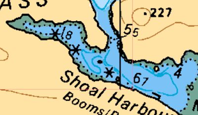
Temperatures are cooler here in the Broughtons. Very comfortable 15°-23°C. We've been to a couple new-to-us anchorages (Simoon Sound; Shoal Harbour*) as well as several regualr favourites, and finally visited with Billy Proctor and his great little museum near Echo Bay (while we were anchored in nearby Shoal Harbour).

[*Shoal Harbour is very poorly charted. We've done an "as you go" depth survey, and now have a more-detailed "chart" of Shoal Harbour... for our next time or others.]


Shoal Harbour: current chart

 
Shoal Harbour: Satellite image with soundings (corrected for tide level)  Click on to view.
 

We spent an enjoyable 5 nights with Carousel before they had to head back South (catching a flight to Nova Scotia at the end of July). We also met up with Chanter, who had family visiting them (5 people on a 34-foot sailboat!) -- we properly socialized with Chanter later once family had to leave.

We've re-provisioned in Port McNeill, and are now in old favourite Sointula. Always relaxing.

Chanter left today for the Cape Caution area. We plan to leave tomorrow morning and also head to near to Cape Caution. After that will depend on weather and us....


Friday, 25 June 2021

Repairs and more delays...

June 25, 2021
Decided to head up to Ha'thayim/VonDonop... a little closer to the rapids but still in warm water (swimming in the sea).

Just as we were coming to our usual anchor spot, our gear shift at the binnacle stopped working. After a minute of (usual) confusion, we found we could still use the gear shift at the inside steering.

After anchoring, we inspected the cable in the engine room. Didn't look good (we eventually found it had snapped within), so a trip to Campbell River for repair would be required. Of course, it was Friday afternoon, so nothing could be done until Monday morning.

We also had a very tiny leak (1 drop/day) at a joint in our hydraulic steering (duscovered the day we left Vancouver), so we decided to get it looked at too.

We headed over to Discovery Marina on Sunday, and were at the Ocean Pacific Boatyard at 8am Monday morning. Although very busy, a mechanic came to our boat by 11am.

Gear shift was simple (a new cable). The tiny hydraulic leak seemed more problematic. It was so small, Mike the mechanic seemed to feel we shouldn't "open a can of worms". But since we were there and had his attention, we decided to try taking off the connection. Doing so, Mike couldn't see anything wrong, and importantly, the flared connection was nothing standard. To replace would mean replacing 2-3 metres of copper line. Parts would need to be ordered. There was always the small chance the fitting simply needed tightening. We decided to have Mike put alback and tighten, and we'd reconsider issue in the off season.

After two nights in Campbell River, we headed back to Von Donop (we couldn't go North from CR because Seymour Narrows was flooding strongly (12+ knots) against us.

We had lost at least 4 days due to this repair trip. By then, the gales in Johnstone Strait had started up. We would have to wait for another window.

On the other hand, Von Donop was nearly empty, not even 25% of the usual number of boats. And the weather was sunny and the ocean temperature warm (22°C).

We were planning to meet up with cruising friends (SV Carousel and SV Chanter) up in the Broughtons, supposedly tomorrow or the next day. But delays (COVID-19 restrictions, 2nd shots, repairs) and then Johnstone Strait gales have set us back.

Never a good idea to try to adhere to a schedule when cruising. The cruising gods will have other ideas.

Frankly, we felt like spending more time in Desolation Sound; we had hot weather, warm swimning to cool off, and once-in-a-lifetime empty anchorages (anchorages that will be filled-up soon, especially if the USA/Canada border reopens late July).

So, we headed from Von Donop back down to Roscoe Bay in Desolation Sound, which we found also nearly empty (only 4 boats, compared to 30+) and warm swimming.

On another positive note: we have yet to see a drip from the hydraulic steering!

Thursday, 17 June 2021

Great sail... intraprovincial travel now allowed

June 17, 2021
The within-BC travel restrictions have been lifted. Yay!

Had a great downwind sail from Pender Harbour to Powell River (25nm) then motored to Cortes Bay. Very empty.

Did some rambling (hiking) through the myriad of trails in K'Was Park on Cortes. Lovely day. Anchorage quiet; RVYC docks almost empty, and, of course, Seattle Yacht Club docks empty.

Great to have Desolation Sound just for BC boaters (that will change soon).

Monday, 14 June 2021

Summer cruising...

June 14, 2021
Where we are going and for how long is up in the air, but today we began our Summer cruise. Motored up to Pender Harbour.

British Columbia has had regional travel restrictions (due to COVID-19), which meant we could not sail to the Gulf Islands or, indeed, 90% of the BC coast. (Boaters on Vancouver Island, by contrast, could cruise 90% of the coast below the top of Vancouver Island.) These restrictions are due to be lifted tomorrow... we hope.

We decided to delay leaving due to the restrictions AND so we could get our 2nd vaccine shots (Moderna) before leaving. The second shots laid us liw in bed with flu-like symptoms for more than 24 hours. So, more of a delay. But, we're now fully vaccinated!

We will head out to Cortes Island tomorrow - - expecting a sail - - assuming restrictions lifted.

We don't know where we'll go this Summer. BC Parks and Conservancies North of Cape Caution remain "closed", likely at the request of local First Nations. Haida Gwaii opens to us July 1st, but one nornally goes up the mainland coast, where Parks are closed. West Coast of Vancouver Island is mostly open. We'll see.

Monday, 7 June 2021

"UPDATED" NAVIONICS AND C-MAP CHARTS ARE OFTEN NOT "UP-TO-DATE" (Canada)

UPDATES (Sept 25, 2021): I have reached the conclusion that you cannot depend upon Navionics (or CMAP) charts to be "up-to-date" within a reasonable time. I find too many incidences of CHS chart updates (for new rocks, shallows, etc) that are not shown on Navionics, even several months later.  

In my view, relying solely/primarily on Navionics charts is not safe.

June 3, 2023: (i) There is new (May, 2023) CHS detailed charting for Tasu Sound (Haida Gwaii) on vector charts. Navionics does not yet include this new charting. Stay tuned! (ii) The new rock and sunken wreck in Thetis Island's North Cove charted by CHS in the Fall of 2021 are still not indicated on Navionics, 1.5 years later! 

December 2023: More than TWO YEARS LATER, Navionics finally includes Thetis Island North Cove updates  ALSO: Navionics now includes new Haida Gwaii charts (5 mos later...). 

February 2024: C-MAP finally includes the new (May/June 2023) Haida Gwaii Charts.


You may think (hope) that your just "updated" Navionics or C-MAP charts  are now "up-to-date". This is not necessarily the case (applies to both app and card-based updates).

Recently, checking "Notices to Mariners" (NOTMAR: https://www.notmar.gc.ca/monthly-mensuel-en.php) by Canadian Hydrographic Services (CHS), I noticed the February version indicated newly discovered rocks/shallows in the general area near Discovery Islands and Desolation Sound.

Below are images from official CHS Raster charts from May 2020 and June 2021:

The updated CHS charts (June, 2021) show the two new drying rocks in Manson Passage (top, right) and the 0.3m shallows in Plunger Pass (bottom, right). Both are dangerous to most boats (especially the shallow area in Plunger Pass, which we passed through last summer).


What about Navionics and C-MAP? As of June 7, 2021, neither show these updates. This includes the C-MAP App and C-Map SD card (card purchased in May, 2021) as well as the Navionics App (as well as the online viewer).

Manson Passage: Navionics (June, 2021, not accurate)

 
Plunger Passage: Navionics (June, 2021, not accurate)


Manson Passage: C-MAP (June, 2021, not accurate)

Plunger Passage: C-MAP (June, 2021, not accurate)

At least 3 months after CHS issued a NOTMAR about these rocks/shallows, yet they are still not shown on "updated" Navionics or C-MAP charts.


Update (August, 2021): Navionics finally updated the above locations by August 14th, 2021. By December 2021, C-MAP updated these locations.


HOWEVER:

The September CHS NOTMAR had new shallows, rocks and wrecks. For example: Here's another  "new" rock and a wreck (North Cove, Thetis Island) shown on the up-to-date CHS raster chart, but not (yet, as of November 20)) on the just-updated Navionics or CMAP:


Keep an eye out to see how long it takes Navionics (or CMAP) to include these updates! 

November 20, 2021: neither Navionics or CMAP have included this September update.)

January 2022: Navionics still doesn't include this update, whereas CMAP does. 

June 2023: Navionics STILL DOES NOT INCLUDE THESE HAZARDS (1.5 years after they were updated by CHS!)


IN CONTRAST, O-CHARTS SEEM TO QUICKLY UPDATE:

O-Charts (https://www.o-charts.org/) makes CHS ENC Vector charts available for OpenCPN  at a very reasonable annual price (20 Euros for Pacific Coast of Canada). These charts can be updated monthly, and are supposed to be the same as CHS ENC charts. 

(OpenCPN is an excellent free/near-free chartplotter software for Windows, Mac, Linux and Android.)


By March, 2021, the O-Charts for Manson and Plunger Passages included the February update:

Manson Passage: O-Charts (March, 2021 -- accurate!)

Plunger Passage: O-Charts (March, 2021 -- accurate!)


Update: just checked earlier NOTMAR editions: current Navionics and C-MAP missing more rocks/shallows in other areas of BC! (O-charts, however, are correctly updated.)


CONCLUSION: Commercial charts such as Navionics or C-MAP may NOT be up-to-date (even though you just "updated" them). "New" rocks and shallows shown on up-to-date official charts may be missing on Navionics and/or C-MAP!


On Pelagia, we ensure our CHS charts are up-to-date. Though we also have Navionics and C-MAP, we but put much greater trust on the CHS raster charts (we are still getting used to the O-charts -- so far, so good.)


Tuesday, 11 May 2021

Short cruise over to Gambier Island (May, 2021)

Port Graves (from Bert's Bluff, Gambier Island)

First time out before the Summer. Headed over to Gambier Island (Howe Sound) and anchored for a couple nights near Camp Artaban.

Did a long hike, first up to Bert's Bluff, then along a route-only "trail" (trail markers but no "trail") from Bert's Bluff to Lost Lake, then back to Artaban via a real trail (albeit, not easy). A tiring day!

Didn't get much "sailing" in, but it was nice to get out (especially since we hadn't skied since March).


[The Provincial Health Officer ordered Whistler-Blackcomb Ski Area to close back in March, due to Covid. Not unexpected, given the large number of visitors to Whistler from Alberta, Ontario, Quebec, and even, somehow, the USA. Whistler's case numbers exploded in February/March.]

Monday, 8 March 2021

Saving depths as you go...


 UPDATE, March 26, 2024: revised version (adds UTC time to output; minor fixes) uploaded [NMEAtoXYZ-3c]


This post is part of a series concerning obtaining/creating more-detailed depth information.

Note: this particular post is technical and may not be of interest to some....


Entering an unfamiliar (and poorly charted*) bay, it would be nice to have a record of depths as we explore. In such cases, however, one must focus on safely navigating, rather than noting down or saving depths.

* In B.C., many bays and coves on up-to-date, decently charted areas often have only a few soundings.


OpenCPN Voyage Data Recorder

Our GPS, AIS, and depth/wind/speed information are now available via WIFI for use by our ship's computer and Android tablet running OpenCPN chartplotting software. OpenCPN is fantastic. Among its many free plugins is the "Voyage Data Recorder", or VDR. When VDR is set to "record", it saves all the NMEA sentence information (including AIS, latitude, longitude, depth, etc) into a text file, until the recording is stopped. A short example of a NMEA text file is shown below:

Sample section of a NMEA text file

In the above sample, !AIVDMs are NMEA sentences for AIS info, $IIDPTs are depths, $IIMWVs are wind, $GPVTGs are speed and course over ground, and $GPRMC, $GPGGA, $GPGLL sentences provide GPS location (Lat/Lon), time, date, course and other GPS information.

The depth information in a NMEA text file does not contain location (Lat/Lon) info. However, there is always such information within less than a second of the depth sentence. We have written a short program to associate NMEA depth info with location, and to save these depth points into two types of files. NMEAtoXYZ is a simple program for Windows PCs that inputs a NMEA text file, and outputs (i) a GPX file of depth waypoints, and (ii) an XYZ file of the same points.  The program gives the user the option to correct depths for tide level (recommended), and to determine the spacing (in time, thus distance) between depths. #

A GPX file can be imported into any GPS or chartplotter. The XYZ file can be used by software to produce satellite image chartfiles WITH depths plotted (see below).


The following screenshots show the process and output:

Playback of VDR recording in English Bay. Pelagia is shown as the red boat with a red trail. [The green triangles represent AIS broadcasted from anchored (black dot) and moving (with line of projected course in front) ships.]


Zoom in on Pelagia (with Tug & Tow heading in opposite direction)


NMEAtoXYZ-3a: GPX output

Depth waypoints (S2Z22 highlighted) saved to GPX by NMEAtoXYZ program


Waypoints are coded in two ways: Arrow symbol and 1st two characters of waypoint name

S2xxxx: Magenta arrow: Depth >20m

S1xxxx: Blue arrow: Depth >2m to 20m

S0xxxx: Red arrow: Depth ≤2M

The symbols are specific to OpenCPN; the waypoint name will work with all GPSs and chartplotters


NMEAtoXYZ-3a: XYZ output

Using SASPLANET and SAT2CHART programs, the XYZ file's depths may be plotted on to a satellite image of the area. This image may then be displayed as a "chart" on OpenCPN. (Full details are explained in SAT2CHART's HELP pages.)

Satellite image chart with depths

The number of depths points plotted by SAT2CHART depend on the zoom factor (higher zooms = more points, when available)


One may also plot these depths on (i) an image of a Navionics chart (using SASPLANET & SAT2CHART) or (ii) on an existing raster chart using a GIS program such as QGIS.


Depths plotted on CHS chart (using QGIS)

The above examples are from Vancouver Harbour. Obviously, such a well-charted place does not require one to be saving depths and making image charts with depths are not required (it's just a test example).

However...

British Columbia still has some areas where nautical charts contain NO depth soundings (for example, parts of the West coast of Haida Gwaii). Even more common, many bays and coves in BC, even in Southern BC, have very limited depth details. A good example is the entrance to Von Donop Inlet/Ha'thayim Marine Park, which we described in a recent post

As we cruise this coming Summer, we hope to obtain more-detailed depth information for the places we visit using (i) the VDR feature of OpenCPN and the above programs, as well as (ii) more-detailed scans using our Deeper Pro+ portable sounder.


The NMEAtoXYZ program (with helpfile) is available free to download from the following link (USE AT YOUR OWN RISK!):

Download latest program update from this link:

https://drive.google.com/file/d/1-YGVXu7k-fYrXD9hWwD5g1E3f5U3m2q8/view?usp=sharing                                      

Note, it has only been tested on a PC running Windows (it MAY work on Linux and MacOS, but these have not been tested).  It is a very simple program (written using QB64), currently with no GUI.  NMEA VDR file plugin and OpenCPN are available for most platforms, except those running iOS. 


# FYI: Reefmaster is commercial software (US$200) that also will save depths with lat/lon, plus a lot more.