Showing posts with label weather. Show all posts

Thursday, 18 December 2025

No sailing this Fall...


We had planned to head out for 5-7 days over Canadian Thanksgiving (October). But Thursday before Thanksgiving, David came down with a bad cold that shut him down for a couple days. And the weather that weekend was truly horrible, with torrential rains.

Weather for the rest of the Fall continued to be pretty lousy.

So, no trips out on Pelagia this Fall. 

Thursday, 14 July 2022

Last days in Haida Gwaii, then a fast "day" sail across Hecate Strait

Kayaking in Anna Inlet (the williwaws are coming!)

After Rose Harbour, we has a sunny, calm motor up to the mooring buoy at Section Cove, where we had nice walk on the beach and a quiet night. We then headed north to the water dock at Shuttle Island/Hoya. A busy place, two boats filled up just before we arrived. Thankfully, the water was plentiful (although a little brown with tannins: we chemically treat the water, and for drinking water, we first filter it with a ceramic&charcoal filter that removes sediment, tannins, bacteria and, importantly, any parasites such as giardia and cryptospiridium).

We moved on a couple miles to Echo Harbour for a nice night. Southerly gales were forecast, so we "thought" our old favourite Anna Inlet would be a great spot. Anna Inlet IS a great spot, but this 4th visit we learned it gets big williwaws when there are southern gales outside. All was calm and quiet (and rainy), when suddenly we were hit with a 31-kn williwaw, and later a 33-kn williwaw. This continued for about 6 hours. We dragged anchor and had to letout a lot more rode. All very unpleasant.

[Turns out, the best place to avoid williwaws on Moresby's east coast is the water dock.]

Our anchor watch in Anna Inlet -- shows we moved all over the place during williwaws
 

After 3 nights in Anna, we motored south back down to Ramsay Island cove (with another stop to fill up water on the way). The plan was to leave the next morning to sail/motor across Hecate Strait, to an anchorage 72 miles away. So hopefully trip fully within daylight hours. But first, we had a visit from a charter boat skipper on the mooring buoy next to us came over to barter: if we had some extra beers, he had some prawns and ling cod. We just happened to have 4 beers we were not fond of, plus some ginger ale for their non-drinking guest. In return, we received a large piece of ling cod and perhaps a dozen prawns.  

Next morning, we were up at 430 am, and motored away in the twilight. Based on the forecast, we expected we would be motoring. As it turned out, we had a fast sail in 12-15 knot SW winds that gave us a beam reach all the way across Hecate. The last few hours the winds picked up to 19-21 knots, so it became a little rambunctious, and seas also picked up. Coming into Caamano Sound, we had to reduce sail and the seas were quite rough. Our chosen anchorage, Gillen Harbour, was supposed to be good in all weather, but its entrance fully open to the south and it looked too rough. We decided to keep sailing, all the way to Chapple Inlet, where we headed up to our earlier spot at the head of the inlet, finishing about 6:30pm. We travelled 93 nm that day, and sailed 68 nm of them (record long "day trip" stats for us), averaging 6.5 knots sailing. 

Hecate crossing in daylight: Ramsay Island to Chapple Inlet (93 nm)


Exhausted, we celebrated our crossing. But then we had southeast gales forecast starting the next night....


Wednesday, 15 June 2022

Shearwater to Prince Rupert: A very rainy, blustery week... then SUN in Prince Rupert

Cow Bay at low tide: Prince Rupert Rowing and Yacht Club

After Shearwater, we ended up in Rescue Bay... in blowing winds and heavy rain. But the winds dies (not the rain) so it was a quiet night.

Next day through Jackson Narrows and past Klemtu (where we were visited by inquisitive crows as we motored by), up through Meyers Narrows to Quigley Creek cove in Laredo Inlet.  Again, pouring rain (but no wind).

Inquisitive crow visiting us as we passed Klemtu

The next day, a surprise: sunshine as we motored up Laredo Channel. However, the forecast for the next days called for gale force winds. So we hunkered down in the head of Chapple Inlet in a cove protected by an island and a headland. The gales indeed did blow outside, but we barely moved in our snug anchorage. But the outside winds kept us there for 3 days/nights!

After 3 nights, forecast was for 20-30 knot southeasterlies --downwind for us. Although grey, often foggy with poor visibility and yes, pouring rain, we had a great 28.5 nm downwind sail to Monkton Inlet.The next day, we had another great 20+ nm downwind sail to Newcombe Harbour (a lovely place... if there had been sun).

We were getting closer to Prince Rupert. Next day, the rains mostly stopped in the morning (but not until after Michelle had to go out into the rain to raise the anchor) , and we had a calm motor to Kelp Passage anchorage, just 17ish nm from Prince Rupert. All of a sudden, there were many commercial and pleasure boats (we were now back on the main "inside passage" route) and we were also back incell phone coverage. And the rain stayed away.

Raising the anchor in Kelp Passage anchorage
 

We had heard (from "John the Hermit" on Anger Island, who called us on our radio as we passed by) that boat space in Prince Rupert was very limited and pricey. So, assoon as we were in cell range, we called, and received, a reservation at the Prince Rupert Rowing and Yacht Club (PRRYC), where we stayed last in 2002. PRRYC is more of a marina than a "yacht"club -- most of its boats seem to be commercial fish charter boats -- but it is a nice place and helpful.

We stayed 3 nights in Prince Rupert (tonight is our 3rd night). A relaxing time. And it was sunny every day! We very much like Prince Rupert, and highly recommend it.

Prince Rupert's "Sunken Garden"

Tomorrow we head out to prepare to cross Hecate Strait (in 3-4 days) over to Haida Gwaii. Watching the weather, as always.

REMINDER: Check our "Location Tracker" to see where we are each day.


Friday, 6 July 2018

Anna Inlet to Sac Bay to Murchison Island cove (Gwaii Haanas)

After 3 nights in anna Inlet (two of them the only boat), we reluctantly left Anna Inlet. (Technically, one is limited to 3 consecutive days at any one spot in the park, subject to weather. This is not, however, monitored.)

We stopped at the freshwater dock off Hoya Passage to fill one of our water tanks (treating it with the same treatment as we used in and leftover from Mexico), then continued on to Sac Bay in De La Beche Inlet. Another dramatic locations, with the San Christoval mountain range towering over the bay. Again the only boat, the next day we kayaked over to Skittagetan Lagoon and back. SV Carousel rejoined us on the second night.

New-to-us* Sac Bay is known for "williwaw" winds (katabatic winds that rush down into the bay from high up in the mountains) under certain conditions, and we experience a mild version of these on our second night. So we decided to move over to a cove at the entrance to De La Beche Inlet. The entrance into this cove was very narrow and shallow. Carousel draws less and went in first, indicating 14 feet depth. At the last minute, we decided not to chance it and instead head over to Murchison Island (where Carousel had spent 3 nights while we were in Anna Inlet).

Murchison Island cove* and the area around is beautiful (in a very different way than Anna Inlet or Sac Bay), and we were fortunate to get one of the two park buoys.

Unfortunately, our first night at Murchison was marred by two issues. First, we had noticed an American sailing vessel was likely fishing (well) within the Rockfish Conservation Area surrounding these islands. NO fishing with hooks of any sort are allowed in RCAs, in an effort to improve rockfish populations. When the boat came in to the other mooring buoy, and proceeded to gut and clean large rockfish, David could not help but to tear a strip off them for illegal fishing. Their response? "We'll check the regulations" (the Gwaii Haanas guide everyone gets is VERY clear about this, as are fishing regulations in general). We have no patience for this behaviour, especially by visitors.

The other issue our first night was a group of 5 kayakers who decided to party until 2am, including belting out "O'Canada" at midnight (yes, 5 Canadian guys...). Next day David had a friendly conversation with these obviously hungover kayakers who promised they'd be quiet our second night (after all, they had no booze left...).

On our second day, we dinghied over to Hotsprings Island to visit the Haida Watchmen and the hotsprings. The hotsprings stopped flowing after the 2012 earthquake, but they are returning. Not real hot (40 degrees C) but very nice. worth the trip.

Our second night at Murchison Island indeed turned out to be very quiet and calm. (Thank you quiet kayakers!)


*not visited during our 2002 or 2011 trips to Gwaii Haanas NPR.

Friday, 30 March 2018

Detailed description of British Columbia marine weather (Free download)


Environment Canada, Canada's national weather forecaster, provides this detailed, highly informative guide to weather patterns on the B.C. coast, including helpful tips for mariners.

Sample page covering Kelsey Bay (Johnstone Strait) winds

It has been "archived", so not all that easy to search for; here is the direct link to the pdf file (click to download): http://publications.gc.ca/collections/collection_2016/eccc/En56-240-3-2015-eng.pdf

IF the above link is broken, use this link to download:
https://drive.google.com/open?id=12e12WMP7GlHqbyHkBoayfXxxEnBVjfVR

Friday, 30 June 2017

Up Johnstone Strait

With gales and near-gales blowing down Johnstone Strait almosy daily, we've had to pick our passage carefully. Essentially, leaving early in the morning, then getting off the Strait before the winds pick up in the afternoon. (For example, motoring up Johnstone Strait yesterday, we only had 10-15 knot Westerlies against us, with no seas. However, in the early afternoon, soon after we pulled into Chancellor Channel, then Wellbore, and anchored in Forward Harbour, Johnstone Strait winds picked up to 24 knots, gusting to 29.)

We are currently 3 nm from our exit of Johnstone Strait at Havannah Channel. Winds and seas are low. Looks like another successful Johnstone Strait passage.

Update: we got lucky with the current in Chatham Channel, and made it easily to Potts Lagoon for the night.

Friday, 16 June 2017

Weather resources for British Coumbia: post updated


The 2016 post providing information for marine- and land-based weather resources for British Columbia, with an emphasis on getting text-based band-limited forecasts, has been updated (broken/changed links fixed.)

See:
https://sailing-pelagia.blogspot.ca/2016/05/marine-weather-forecasts-for-british.html

Friday, 18 November 2016

Back home in Whistler, BC: Snow on the mountains!

We are now back home in Whistler.

While away in Nepal, a warming trend melted much of the snow on the mountains. However, it has been (and is currently) snowing, and we fully expect to be skiing next week!

We have updated our preceding blog post (with photos) concerning our Poon Hill/Annapurna Base Camp treks, and have posted all our Poon Hill/ABR trek photos on an album on our FLICKR account:
https://www.flickr.com/photos/sv-pelagia/albums/72157675133841272 

Friday, 6 May 2016

Marine weather forecasts for British Columbia: Sources for band-limited access (e.g., text forecasts for cell phone, HF-SSB/HAM and/or Satellite Phone) [Updated June, 2017]

All of BC Coast (zoom in to view)
Last revised: June 16, 2017 (broken links fixed)
As we prepare to head north to the central coast of British Columbia, we are updating and collating sources for accurate (i.e., Environment Canada) marine weather forecasts, with a particular eye towards obtaining these forecasts using band-limited methods: (i) via High-Frequency Single-Sideband (HF-SSB) radio (Marine band Sailmail and HAM Winlink), and (ii) via pay-per-MB cellular data services.


To SKIP following Introduction, PAGE DOWN  and go DIRECTLY TO BANDLIMITED SOURCES FOR BC WEATHER

Marine forecasts from Environment Canada (as well as land-focused weather forecasts) are available on the web and, importantly, via standard VHF marine weather stations throughout most of the British Columbia coast. The images above provide an overview of the forecast regions (titles in red), names/locations of shore-based weather stations, and names/locations of ODAS weather buoys. The image below below zooms in on the "Georgia Basin".

Georgia Basin

Mariners new to BC waters are recommended to download Environment Canada's summary/explanation of marine forecasts for British Columbia waters:  available as a pdf here.

A very detailed description of BC marine weather is found here: http://www.publications.gc.ca/site/eng/9.630051/publication.html, available only as a 5 MB pdf download (The online HTML version is no longer available.).  IF this link is broken, download file from here:
https://drive.google.com/open?id=12e12WMP7GlHqbyHkBoayfXxxEnBVjfVR

ENVIRONMENT CANADA MARINE FORECASTS VIA WEB -- when bandwidth not a concern
When good access to the internet is available, mariners can obtain detailed marine forecasts from Environment Canada using their web browser-- note, these websites can eat up cellular data

South Coast -- Georgia Basin (Straits of Juan de Fuca up to Johnstone Strait/Estevan Point):
URL: http://weather.gc.ca/marine/region_e.html?mapID=03

South Coast (includes Georgia Basin, all of Vancouver Island, central BC coast up to McInnes Island)
URL: http://weather.gc.ca/marine/region_e.html?mapID=02

North Coast  (North end of Vancouver Island to Alaskan border)
URL: http://weather.gc.ca/marine/region_e.html?mapID=01

One issue with viewing forecasts from the web is that one typically does not retain a copy of the forecast as one switches between webpages, unless one intentionally makes a copy of the forecast. This makes it difficult to review forecasts.  The text-based forecasts (for bandwidth-limited methods) discussed below provide methods to retain these forecasts for later review.


ENVIRONMENT CANADA MARINE FORECASTS VIA VHF MARINE RADIO
Importantly, marine forecasts from Environment Canada (as well as land-focused weather forecasts) are available via standard VHF radio marine weather stations throughout most of the British Columbia coast. The VHF weather channels and regions are indicated in the images above. Due to British Columbia's complex topography, with its high mountains, deep fjords, and thousands of islands, which specific channel to use for any given bay/cove is not always obvious. The images above are helpful, but the best method is simply to try multiple channels.^ 

However, there are isolated areas where these forecasts can be difficult to obtain via VHF radio (either non-existent or very broken up), such as deep in the many fjords of the BC coast and Vancouver Island (Princess Louisa Inlet and Vancouver Island's Kyuquot inlets, for example, have NO VHF weather). Moreover, these VHF broadcasts can be problematic for weather planning as (i) although repeating, if one misses a region, it takes a while to hear it repeated, (ii) it can be difficult to keep track of/recall of the many forecasts given over the VHF radio (here is where making an audio recording of the forecast could be helpful), and (iii) the forecasts available for a given area may not include a region one is planning to cruise to in a few days. The text-based forecasts (for bandwidth-limited methods) discussed below provide methods to solve these issues.

^In addition to marine weather channels, there are also public weatherradio channels on marine VHF (and/or AM or FM radio). These channels provide weather for shore-based areas in both English and French and also repeat marine weather forecasts. For frequencies, see http://www.ec.gc.ca/meteo-weather/default.asp?lang=En&n=770985EF-1

BANDLIMITED OPTIONS FOR WEATHER FORECASTS:

Why do we need "bandlimited" (small data size) options?

* Bandlimited weather forecasts can be downloaded very quickly.  


* Bandlimited weather forecasts incur little data cost for services that charge per MB (cell data, satellite).  


  • Internet access (via WiFi) is often very slow and/or "spotty" (cuts in/out). This is the case for WiFi in many marinas. [Note: a Wifi amplifier is very helpful. This could be more-expensive options such as the Wirie (at least US$400), the better-priced Wave RV Marine (US$169), or the many inexpensive Wifi "range extenders/amplifiers" available from online sources such as Amazon.)
  • Internet/data access costly (priced in $/MB) -- this is especially the case with cell phone data plans
  • Internet not accessible: no WiFi and no cell phone coverage. This is the case for most British Columbia waters. In these cases, one relies on to audio forecasts on marine VHF radio.
  • Alternatively, one can obtain forecasts anywhere/everywhere via HF-SSB ("shortwave") Radio and Pactor Modem  or satellite transceiver such as Iridium GO!  However, access to weather forecasts by both HF-SSB Radio/Pactor Modem and satellite transceivers are limited by (relatively) slow data speeds (before data compression: <2400 BAUD for Pactor3; <5512 BAUD for Pactor4;  ~2400 BAUD for satellite services). Satellite services are (usually) further limited by data cost (although there is a US$159/month "unlimited" data plan for Iridium GO!).
How does one access bandlimited weather forecasts?
  • HF-SSB/Pactor or Satellite service: send request ("query") to "Saildocs" via email service (e.g., HAM-based "Winlink" email*, often using "AIRMAIL" program, Sailmail-based email# using "AIRMAIL" program, Satellite-based system using Sailmail or other system. Send text-only email to Saildocs, then 1-2 minutes later to see text forecast
             * Winlink email service free and unlimited (no "business" use); however, requires HAM radio license 
             # Sailmail email service US$250/yr; requires marine radio "station license"; limited to 90 minutes connection/week
  • WiFi internet/cell data plan: using your email service, send request to Saildocs, same as above 
  • WiFi internet/cell data plan: go to the specified URL (e.g.,http://weather.gc.ca/marine/marine_bulletins_e.html?Bulletin=fqcn13.cwvr). (Remember to save the displayed forecast)
  • GRIB-file computer-generated weather forecasts: send "grib" request to Saildocs, as described below

Saildocs:  (From the Saildocs website) Internet services for the bandwidth-impaired. Saildocs is an email-based document-retrieval system for the delivery of text-based Internet documents either on request or by subscription. Saildocs can deliver web pages (including text weather forecasts, and provides subscriptions for automatic delivery. Additionally Saildocs provides custom grib weather-data files per request from data downloaded from NOAA/NCEP and other sources.  Saildocs offers text-based document retrieval and subscription services for offshore sailors, adventurers, missionaries and others who must somehow live their lives without fiber, DSL or even 56Kbaud dialup connections. There are currently two services offered, a document retrieval service which will return documents from the Internet or our own files, and a subscription service which will send Internet documents (for example weather reports) at scheduled intervals.

Saildocs can also fetch documents from the web and convert them to plain text. This often results in a little extra (and irrelevant) text added before/after the information (forecasts) of interest, but it rarely adds much in terms of datasize or download time. 

The services provided by Saidocs are free and open to anyone -- one does not need a HF-SSB radio or satellite system to use Saildocs.

For full information, go to http://www.saildocs.com/info or send an email as follows:
To: query@saildocs.com
Subject: (anything you want)
send info
send index


Saildocs also has short versions of request for text forecasts. Oddly, the "send xxxxx" command doesn't always correspond to the Environment Canada file name. The list below provides these short commands, which were tested as of April 2016 (short commands tested denoted by "+").

==============================================================================================
skip to here...

BRITISH COLUMBIA WEATHER FORECASTS: BANDLIMITED OPTIONS

The following provides URLs for web and Saildocs access to Environment Canada's text-based forecasts. In some cases, Saildocs has a shortened command to receive these files.&

Environment Canada's forecasts all involve expert human (meteorologist) interpretation and modification of computer-generated forecasts. In most cases, these forecasts take into account complicated shore effects (something which strictly computer-model based forecasts -- such as GRIB files -- do not provide).

& USA-based NOAA also provides access to all  Environment Canada text weather forecasts using its FTP server: see http://tgftp.nws.noaa.gov/ftpmail.txt. These may be accessed by sending URL to Saildocs or by direct ftp request to NOAA ftp server. (In 2016/2017: NOAA discontinued direct web access to its FTP server.)


BRITISH COLUMBIA MARINE FORECASTS
 
Marine Forecasts (Days 1 & 2) for the ALL British Columbia waters
Text file: FQCN13.CWVR
URL:
http://weather.gc.ca/marine/marine_bulletins_e.html?Bulletin=fqcn13.cwvr
Saildocs: send http://weather.gc.ca/marine/marine_bulletins_e.html?Bulletin=fqcn13.cwvr
+Saildocs (short version): send fpcn20.cwvr

Extended Marine Forecasts  (Days 3, 4 & 5) for ALL British Columbia waters
Text file: FQCN53.CWVR
URL: http://weather.gc.ca/marine/marine_bulletins_e.html?Bulletin=fqcn53.cwvr
Saildocs: send http://weather.gc.ca/marine/marine_bulletins_e.html?Bulletin=fqcn53.cwvr
+Saildocs (short version): send fpcn54.cwvr

Wave Height Forecasts (Days 1 & 2) for the Pacific waters (i.e., areas exposed to open Pacific waters)
Text file: QCN23.CWVR
URL: http://weather.gc.ca/marine/marine_bulletins_e.html?Bulletin=fqcn23.cwvr
Saildocs: send http://weather.gc.ca/marine/marine_bulletins_e.html?Bulletin=fqcn23.cwvr

"Marine Synopsis" and "Marine Weather Statement" for Pacific Waters   (Provides a general picture of the position and motion of the main weather features (lows, highs, fronts).
Text file: FQCN10.CWVR
URL: http://weather.gc.ca/marine/marine_bulletins_e.html?Bulletin=fqcn10.cwvr
Sailmail: send http://weather.gc.ca/marine/marine_bulletins_e.html?Bulletin=fqcn10.cwvr


BRITISH COLUMBIA FORECASTS FOR SHORE LOCATIONS
(focus on land-based weather priorities, including temperatures, sun/cloud/rain; not mariner-focused but still very much of interest)

Shore forecasts for the south coast of British Columbia (Days 1 & 2)
Text file: FPCN11.CWVR
URL: http://weather.gc.ca/forecast/public_bulletins_e.html?Bulletin=fpcn11.cwvr
Saildocs: send: http://weather.gc.ca/forecast/public_bulletins_e.html?Bulletin=fpcn11.cwvr


Shore extended forecasts for (ALL) coastal British Columbia (Days 3, 4, 5, 6 ,7)
Text file: FPCN50.CWVR
URL: http://weather.gc.ca/forecast/public_bulletins_e.html?Bulletin=fpcn50.cwvr
Saildocs: send http://weather.gc.ca/forecast/public_bulletins_e.html?Bulletin=fpcn50.cwvr

Shore forecasts for the central and north coast of British Columbia (Days 1 & 2)
Text file: FPCN12.CWVR
URL: http://weather.gc.ca/forecast/public_bulletins_e.html?Bulletin=fpcn12.cwvr
Saildocs: send http://weather.gc.ca/forecast/public_bulletins_e.html?Bulletin=fpcn12.cwvr
+Saildocs (short version): send fpcn11.cyxy


BRITISH COLUMBIA: CURRENT MARINE OBSERVATIONS 
(e.g., wind speed/direction, temperatures, wave heights, etc)

The easiest method is to get the "Regional Summaries", which provide (when available) in the following order:

Wind(knots)     Wave height(m)     Wave period(s)     Pressure(kPa)     Air temp(°C)     Water temp(°C)

Note: the translation by Saildocs of these regional summaries is a little garbled but still quite readable, provided one keeps in mind the above order of values.

Regional summary: South Coast
URL: http://weather.gc.ca/marine/weatherConditions-regionalSummary_e.html?mapID=02&siteID=06400&stationID=VTF
Saildocs: send http://weather.gc.ca/marine/weatherConditions-regionalSummary_e.html?mapID=02&siteID=06400&stationID=VTF

Regional summary: North Coast
URL: http://weather.gc.ca/marine/weatherConditions-regionalSummary_e.html?mapID=01&siteID=03407&stationID=46183
Saildocs: send http://weather.gc.ca/marine/weatherConditions-regionalSummary_e.html?mapID=01&siteID=03407&stationID=46183

Regional summary: West Coast Vancouver Island
URL: http://weather.gc.ca/marine/weatherConditions-regionalSummary_e.html?mapID=02&siteID=15300&stationID=WFG
Saildocs: send http://weather.gc.ca/marine/weatherConditions-regionalSummary_e.html?mapID=02&siteID=15300&stationID=WFG


Reports from all staffed "Lightstations" (lighthouses) in British Columbia (South & North Coast)
These reports are provided by the lighthouse keepers, and include observations about visibility, cloud cover, fog, and seas.  These reports are somewhat coded using abbreviations -- for details, see http://www.ec.gc.ca/meteo-weather/default.asp?lang=En&n=3D8459C9-1

URL: http://weather.gc.ca/marine/weatherConditions-lightstation_e.html?mapID=02&siteID=06400
Saildocs: send http://weather.gc.ca/marine/weatherConditions-lightstation_e.html?mapID=02&siteID=06400


GRIB FILE FOR BC COAST FROM SAILDOCS
(from Saildocs)Grib files are computer-generated forecast files from a NCEP/NOAA computer, which are sent without review, and are offered on an as-is basis. There is no assurance that the data is available, accurate or correct. Both Saildocs and the computer model itself are automated systems, subject to a variety of failures and errors. Grib files do not indicate the very-complicated shore effects that occur in BC's waters -- for details, see https://www.ec.gc.ca/meteo-weather/default.asp?lang=En&n=7C8C8223-1   such as  (for example): Summer inflow/outflow winds in fjords, Winter "Squamish" outflow winds in fjords such as Howe Sound, gap winds such as "Qualicums", katabatic (williwaws) winds down mountain slopes, and "corner winds" produced near large capes/points (the worst being winds around Brooks Peninsula).


For information on obtaining GRIB files from saildocs, see: http://www.saildocs.com/gribinfo

To view the grib file, one needs a grib-file viewer. See:  http://weather.mailasail.com/Franks-Weather/Grib-File-Viewers   OpenCPN can be used to view grib files, overlaid on charts.


  • To obtain a small grib file (every 2 degrees, filesize = 11 KB) for the British Columbia coast, with forecast for every 6 hours out to 72 hours, send the following to Saildocs:
To: query@saildocs.com
Subject: anything you want
send GFS:56N,46N,144W,122W|2,2|0,6..72|PRMSL,WIND,WAVES,RAIN
  • The above request results in a low-detailed GRIB file. To obtain a GRIB file with maximum detail (every 0.5 degrees), send the following request:                    (Note: file size is 76 KB!)
send GFS:56N,46N,144W,122W|0.5,0.5|0,6..72|PRMSL,WIND,WAVES,RAIN
  • To expand the area covered in order to get the "big picture" for weather (e.g., to all of Northeast Pacific ocean), change the Lat/Long. (Note: set detail to 2,2 degrees, otherwise file size will be too large.)

Friday, 18 March 2016

UPDATE: Change (temporary) in Geary's SONRISA NET Mexico weather forecasts from the web and via saildocs

APRIL 10, 2016 UPDATE: It appears that Sonrisa Net weather website is now up and running correctly and obtaining Geary's forecasts via Saildocs now working fine.

Ignore updates etc below....

HOWEVER check out Pelagia's info re Mexico cruising weather (& charts, cruising guides, etc), go to this post:


APRIL 7th UPDATE:
It appears that the Sonrisa Net weather website is now being updated,  except for the "Daily Summary" (still shows February 18th summary) which is updated on Geary's "Blog" on Weather Underground.

Unfortunately,  it does not appear that requests ("queries") to SAILDOCS for Geary's forecasts are working properly (see below for workaround to get forecast via Saildocs) .


Important Update March, 2016:
Geary's SONRISA NET weather website and associated Saildocs files for the Pacific coast of Mexico (especially Baja and the Sea of Cortez) have not been updating over the past month.

HOWEVER: He still does his daily forecast over HAM radio on the Sonrisa Net AND publishes an up-to-date forecast on his blog on the Weather Underground website:

http://www.wunderground.com/blog/Geary/show.html

To get a copy of Geary's latest forecast from SAILDOCS, send the following to SAILDOCS (replace the date: the example is for March 18, 2016):

send http://www.wunderground.com/blog/Geary/gearys-sea-of-cortez-weather-for-031816

NOTE: Saildocs will send a copy of the html file as a text file. This message will be unreadable until is saved as a .html file, and then read by your web browser.


The July 2014 post regarding Mexico weather info has been updated:
http://sailing-pelagia.blogspot.ca/2014/07/information-for-cruising-mexico-charts.html

Thursday, 3 December 2015

2015: A very busy season for hurricanes in the Eastern Pacific and Mexico


According to NOAA, the 2015 Eastern Pacific Hurricane Season was a record-setting season:

The eastern Pacific saw 18 named storms, including 13 hurricanes, nine of which became major.  This is the first year since reliable record keeping began in 1971 that the eastern Pacific saw nine major hurricanes. Hurricane Patricia was the strongest hurricane on record in the Western Hemisphere in terms of maximum wind speed at 200 miles per hour and lowest air pressure at 879 millibars. Hurricane Sandra, which formed at the tail end of the season, was the strongest hurricane in the eastern Pacific so late in the year, with a maximum sustained wind speed of 145 miles per hour.

The central Pacific shattered its records too, with 14 named storms, including eight hurricanes, five of which became major hurricanes, the most active season since reliable record-keeping began in 1971. Three major hurricanes (Ignacio, Kilo and Jimena) churned at the same time east of the International Dateline, the first time that was ever recorded.

2015 Tropical Storms/Hurricanes

Source: NOAA


Hurricanes approaching Baja California as early as early June (H. Blanca) and as late as late November (H. Sandra).

Something to think about when planning sailing to/from Baja California!

Friday, 23 October 2015

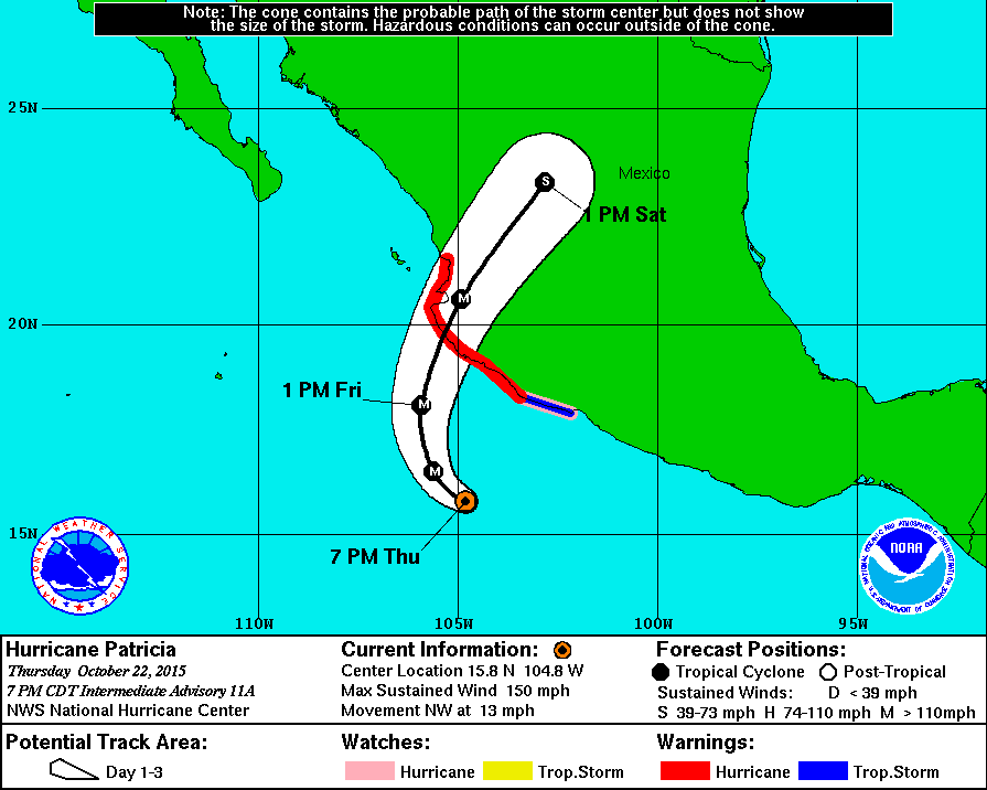
Super Hurricane Patricia comes ashore near Manzanillo

A huge hurricane,  Patricia packed winds of at least 150 knots.  Coming ashore near Manzanillo,  Patricia is the strongest  hurricane ever to hit the Americas (and possibly anywhere).


Our thoughts go out to friends with boats in the area, and especially to the Mexicans living and working in the area.


AFTER THE HURRICANE UPDATE:
Cruising boats in Barra de Navidad fared pretty well; locals not so well. Friends Betty Anne and David on SV Confidence have a full description of the experience of Hurricane Patricia on their blog: http://cruiseoftheconfidence.blogspot.gr/2015/10/hurricane-patricia-2015-part-three.html

Monday, 17 August 2015

Boat gear Part I: What worked for us in Mexico.

Solar panels!
Part I: New additions that we found to be essential

UNDER CONSTRUCTION:
As boaters prepare their boats to cruise to/in Mexico, we felt we should highlight a few additions we made to Pelagia that we found particularly helpful and, indeed, essential. (This list does not consider gear already/normally on Pelagia, such as the sails, engine, autopilot, chartplotter, radar, etc.)

Readers might also be interested in our other blog posts concerning Mexican charts, weather and communications:

http://sailing-pelagia.blogspot.ca/2014/07/information-for-cruising-mexico-charts.html

http://sailing-pelagia.blogspot.ca/2015/05/mexico-nautical-charts-c-map-and.html

Listed below are some items we feel were "essential" to our successful, safe, and (mostly) comfortable cruising to/in Mexico. The list is not complete (see also future blog posts considering "Less useful" and "nice to have but not essential" items). These lists reflect our personal views -- others might not agree.


"Detailed" notes can be found at the bottom of this post.
4 solar panels over bimini

Solar panels/charge controller:

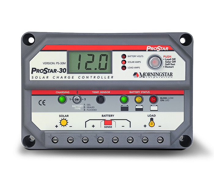
We added four 90W panels to the top of our bimini (and a Morningstar Pro-Star 30-amp PWN solar charge controller [1] installed in a cockpit locker) only a week or so before leaving. This addition changed our cruising life (while at anchor or sailing) -- effectively removing all worries about our battery charging while in Mexico [2].  With so much sun in Mexico, it was common for this system to provide 13-16 amps/hr charging in the midday, and 5-6 amps/hr on cloudier days [3]. We had little worry even with our air-cooled Nova-Kool refrigerator running 24 hrs/day.


Marine SSB/HAM radio with Pactor 4 modem, airmail software, and Sailmail membership:  


This system [4] was critical to us for obtaining marine weather information in Mexico, as well as the Neah Bay-to-San Francisco offshore section [5].  

We wrote about weather forecasting in a previous post. There is no official marine weather forecasting (that we could find) in Pacific Mexico; no forecasts are available the VHF radio [6].  The only forecasts available, all unofficial or experimental, must be obtained in one or more of the following ways: (i) downloaded from the internet, or (ii) audio (i.e., listened to) on Marine SSB/HAM radio [7].  


Audio forecasts are primarily: (i) Geary's excellent (but, nevertheless, amateur) daily forecast delivered on the SONRISA HAM SSB Net each morning, and (ii) Stan's computer-generated (no human input) forecasts read out on the AMIGO Marine SSB net each morning. (These forecasts, plus extra information, are easily downloaded from the internet or by using low-bandwidth email such as SSB/HAM-based or Satellite Phone-based airmail/sailmail and SailDocs.)  


Not to be underestimated, additional real-time on-the-spot weather information is obtained by listening to boaters when they check-in on the SONRISA and AMIGO nets; moreover, individuals may, and often do, request "weather fills" (additional details for specific areas) from Geary; this audio information is not available on the internet or by using a satellite phone.  

Forecasts on the Internet: in addition to Geary's and Stan's forecasts, experimental NOAA forecasts, and other forecasts are available as text files (most easily using Saildocs). GRIB files are also easily available to download (these files are computer-generated "forecasts" in graphic form which have no human input and thus do not take multiple factors into account such as local conditions, topography etc). While at sea or at anchor (and away from broadband or cell-phone based internet), these files can be downloaded using a satellite phone with a data plan or, as we did, using our Marine SSB, Pactor modem, and Airmail software (and Sailmail membership)[8].  Another great feature of  Marine and HAM SSB radios is the ability to talk to other boaters located up-and-down the coast (or on a passage), and to learn the locations of others, often friends, by listening to the SONRISA and AMIGO nets, or other nets such as the Pacific Seafarer's Net (difficult or not possible using a satellite phone).[9]


Shawn & Heather's (Blue Latitude Press) Guidebooks and Waypoints:  

As we noted in our earlier post, the Blue Latitude Press guidebooks are excellent and essential [Sea of Cortez: A Cruiser's Guidebook. 3rd Ed.; Pacific Mexico: A Cruiser's Guidebook]. 

Additionally, we downloaded digital/electronic versions of all their waypoints [10] so that they could be easily transferred to our Furuno chartplotter as well as to a computer-based charting program (OpenCPN) [11]. The guidebooks provide large-scale detailed chartlets [12], with the locations of these waypoints accurately indicated. (These chartlets are also available as electronic charts -- see Note #12.) Given the lack of  accurate and detailed marine charts for most areas of the Mexican coast, Shawn and Heather's accurate waypoints gave us confidence in navigating closer to shore and when anchoring. Download the waypoints, and don't leave San Diego without purchasing these excellent guidebooks [13].


(Bulk) Water Treatment System:  

Before coming to Mexico, have a method to treat water obtained from marina and fuel dock taps. We recommend obtaining a Filter/UV Sterilization system.

Most cruisers reading this heading will immediately think "watermaker", but this is not what we are referring
to. Due to pollution (especially the slightest bit of gas, diesel, or oil), watermakers are rarely useful in marinas, as well as in some crowded anchorages where there may be poor water circulation and/or pollution (e.g., Barra de Navidad lagoon).

We stayed in marinas a lot (especially Marina Palmira, La Paz). A watermaker, if we had one (we don't), would be useless here [14]. Many cruisers purchase water for their tanks; at about C$2.50-$3.00 per 19-litre garrafone arranged through a marina (a little less if you do not need to tip staff from the water company, or deal directly with agua purificada store), filling our tanks (~460 litres or 24 bottles) can really add up (C$60/fill!). Additionally, lugging these large heavy bottles to the boat and the subsequent pouring into the tank fills are a pain. Finally, in many places it can be difficult to find more than a few bottles at a time. We usually used dock water, filtering and chemically treating the water.

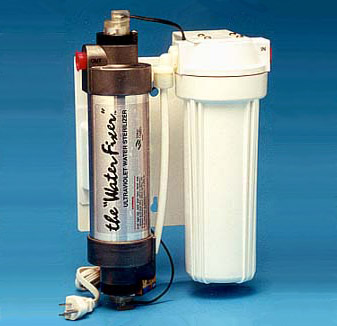
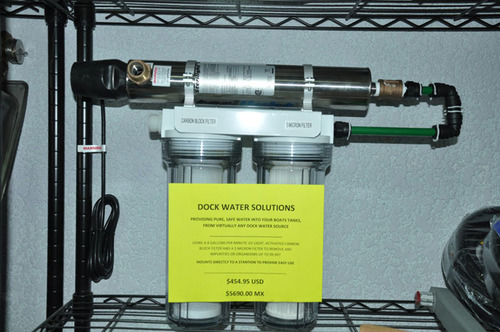
Rather than purchasing water in bottles, some cruisers treat the water at their dock taps using combinations of filters, UV sterilization, and/or chemical treatment.  Waterfixer makes Filter/UV sterilization systems (available directly from manufacturer, or through Downwind Marine in San Diego). Tom at La Paz Cruiser's Supply also sells a filter/UV Sterilization system. One hooks the water hose up to the filter/UV system, applies power (12v or 110v, depending on version purchased), run it a bit to clear filters, then take its output to the boat's water tank(s). The system is portable and can be temporarily hung on the lifelines while filling.

In our case, we first filtered the dock water as we put it into our tanks, then chemically treated each tank (using a solution similar to Microdyn, but a much less expensive Soriana/City club store brand). This system worked well for us [15]. A better system, however, is a combination filter/UV sterilization system, such as noted above.


Fans to cool you off in hot weather:

It gets really hot on the boat in Mexico!  Short of an air conditioner (which we certainly did not have), the primary way of cooling off inside was by using fans (in addition to open hatches and windscoops). Before leaving Vancouver, we installed two fans in the V-berth, two fans in the main salon, and one fan in the galley. All of these fans were Caframo "Bora" 3-speed fans, which were fairly powerful (for their size), (relatively) quiet, and very easy on the batteries.

Be sure to bring multiple spares of your fans: when we returned to Mexico after leaving Pelagia in Mazatlan for the Summer, we found the 3-speed switches on two fans were stuck in one position (rather suspiciously, the two broken fans were next to windows that had been replaced over the Summer -- we believe their problems stemmed from damage occurring when the windows were removed and/or replaced). Fortunately, we had one spare Bora, plus a used spare Hella 2-speed "Turbo" fan to replace the damaged Boras. The Hella Turbo is noisier than the Caframo Bora, and has no protective grid at its back, making it awkward to adjust the fan when it is running. We prefer the Boras.


Bug screens for windows/hatches and companionway:

Whether it is the pesky little mosquitoes whose "bite" carries a real itchy punch (and, possibly, Dengue fever), nasty "jejenes" ("hey-hey-nes", no-seeums) which are tiny and give a rash of itchy sores, or bees searching for fresh water, you need a good bug screen setup for your boat.

Our new Lewmar portlights came with somewhat flimsy but effective bug screens; for the hatches and the companionway, we purchased "Sogeman Bugbuster" screens, which worked very well. These are available direct from Sogeman, as well from many online marine businesses in Canada and the USA.

A real downside to bug screens is that they really cut down on air flow -- a real problem when the temperatures heat up!


Other essential items (we already had on Pelagia)
(i.e, not installed specifically for Mexico)
  • 25-kg ROCNA anchor and 300' all-chain rode, with Lewmar V2 windlass [16]
  • Furuno 1724C Radar/Chartplotter (with annually-updated C-Map card)
  • Wagner S50 Autopilot. Old technology (not computer compatible...), but a workhorse that always kept true 
  • OpenCPN PC-based charting system with official USA and Canada RASTER charts, CM93 worldwide VECTOR charts, and GE2KAP/Google Earth software (for preparing GPS-accurate Google Earth "charts")
  • Nova Kool LT201-RT6 air-cooled refrigerator in ice box with 3-inch insulation [17] Kept items cold; froze meats and kept them frozen; and made ice (using only the RT6 ice box as a freezer). As noted above, our solar charging system had no problem keeping up (and surpassing) the energy demands of this 2.2 amp/hr Nova Kool system.


Detailed notes:

Solar panels/charge controller:
[1] We had planned to obtain a MPPT controller. However, the solar power specialist from whom we purchased the panels and controller strongly recommended a PWN over the MPPT controllers. When we objected ("but online blogs and 'experts' say we must get a MPPT controller...!"), he went so far as to telephone a Morningstar representative, who also agreed with his advice: we would be paying extra money for a MPPT controller but receive no benefit due to the small size of our solar array. For those concerned with electrical noise from the PWN controller during SSB/HAM radio use, we found such noise was only an issue when the PWN controller went into Stage 3 charging; it was simple to turn off the controller when required.
[2] The only time we had concerns with charging and battery levels was on the 3rd day of our Ensenada-to-Turtle Bay passage; all three days (and 2 nights) were cloudy and the combination of sailing, lower panel output, and (too much) use of the autopilot resulted in lower battery levels. Our first day in Turtle Bay, it rained solid for most of the day. This was the one and only time we felt we needed to use our Honda generator.  
[3] Back home in British Columbia, we still seem to be getting 12-15 amps/hr charging late morning until early afternoon on sunny days, and 4-8 amps/hr at other times (and 4-8 amps/hr on days with high clouds).

Marine SSB/HAM radio with Pactor 4 modem, airmail software, and Sailmail membership:
[4] Our Marine/Ham SSB radio is the ICOM M802. This radio can be set to receive/transmit on all Marine and Amateur Radio (HAM) frequencies in the "high frequency" range (i.e., up to 30 MHz), and works very well for us. (However, there are other HAM radios with fewer "bells and whistles" (which we also did not use) available at a lower price.) Rather than the more-complicated ground-plane installation, we used the "KISS Ground Plane" (actually, a counterpoise) -- a very easy installation that worked very well for us (as well as friends on other boats), despite the "kerfuffle" sometimes associated with it.
[5] At times we were over 100 nm off the coast of Washington/Oregon/California, making reception of NOAA weather forecasts on VHF radio sometimes difficult (though, surprisingly, we were often able to receive VHF forecasts this far off the coast). However, even when we could hear forecasts on VHF, we still relied on the text forecasts downloaded using our SSB radio/Pactor modem. NOAA VHF forecasts would usually cover a small area, so it was hard to "look ahead", and equally important, the huge number of forecast regions off the West coast was very confusing, and having these forecasts downloaded and saved in text format made it easier to interpret. (We had very "difficult" weather -- gales and "hazardous seas" -- off of the Oregon/Northern California and we should have been better at evaluating the many NOAA forecasts....) 
[6] In several locations popular with cruisers (La Paz, Puerto Escondido, Mazatlan, Banderas Bay, etc), there are "cruisers' nets most mornings on VHF radio, when weather forecasts are read aloud (usually either Geary's or Stan's). These forecasts on VHF nets are not obtainable when one is farther away or when land mass intervenes. Also, in some harbours (e.g., Puerto San Carlos in Bahia Magdalena), the Port Captain reads aloud (in Spanish) a daily weather forecast on VHF radio. 
[7] Weather forecasts on Marine SSB and HAM SSB may be listened to by anyone, even those without a Marine ROC or an Amateur Radio (HAM) certificate (provided their radio can tune to these frequencies). Technically, a marine ROC ("restricted operators certificate") and station license (outside of USA/Canada) are required to transmit on marine frequencies (VHF and high-frequency marine SSB). A HAM certificate is required to transmit on HAM frequencies. However, in the case of a true emergency, HAM and Marine NETS will take calls from anyone.   
[8] Email access to HAM stations is free to HAMs using Winlink2000. Access to Marine SSB Sailmail requires a US$250/yr membership (and a marine "station license"). In Mexico, we found connections to HAM stations to be difficult, slow and often unobtainable. Sailmail stations, on the other hand, were easy to connect to and much faster than the HAM stations. (This situation continues for us in British Columbia.) 
[9] In the case of an emergency, a broadcast on marine and HAM SSB frequencies and associated NETS will be heard by boats nearby and far -- as well as by land stations --  possibly enabling faster assistance. A satellite phone cannot do this.

Shawn & Heather's (Blue Latitude Press) Guidebooks and Waypoints:
[10] One could, as many do, enter each waypoint manually. However, errors can occur doing it this way, and it is a lot work. The ease of downloading and transferring waypoints accurately makes the low cost of downloading these waypoints (US$4.95 per guidebook) an excellent investment. 
[11] We use GPSUtility to modify and transfer waypoints to our chartplotter (and other GPS systems).
[12] The detailed chartlets in the Blue Latitude Press guides are now available as GPS-accurate electronic charts for PC, Android, IPad and Mac. The charts are the same price for all platforms; however, software required to view these charts is expensive for PC and Mac, but quite reasonably priced for Android ("PathAway" charting software) and IPad ("INavX" charting software) tablets. See Blue Latitude Press and Fugawi X-Traverse websites. We only recently learned about these electronic charts, thus we did not have this while in Mexico. If we were returning to Mexico, we would definitely have these on our Android.
[13] Unfortunately, Blue Latitude Press guides do not cover the Pacific Coast of the Baja peninsula. Most of these areas do not have official large-scale detailed charts (electronic charts such as C-Map and Navionics reflect this lack of detailed charting), and the existing cruising guides, in our mind, are lacking in accurate details (especially, no GPS-accurate chartlets). In a subsequent post, we will suggest using OpenCPN charting software and GPS-accurate "charts" (Google Earth photos) produced using GE2KAP software to provide additional information for sailing down the outside of Baja (and, indeed, for anchorages elsewhere in Mexico).

(Bulk) Water Treatment System: 
[14] We do not have a watermaker. Given Pelagia's large water tanks -- and we plan to install a third water tank, replacing a 30-gallon diesel tank we removed two years ago --  and how much we stayed in marinas, we did not need one while in Mexico. Decent watermakers (e.g., Spectra) are very expensive, both in initial purchase (US$5000-$15,000), installation, and in ongoing maintenance. They require substantial energy to produce water, and usually take up a lot of space. Moreover, watermakers are easily among the most common items to fail during cruising (along with autopilots and refrigerators). So, a watermaker is still not on our "wish" list for Pelagia (although, given current drought conditions in southern BC, especially on the islands, one has to wonder...).
[15] In two seasons of cruising in Mexico, we had food/water-borne sickness only once: Giardia. We have no way of knowing where we picked this up (it takes 8-10 days for symptoms to show up, and they are not that obvious); likely it was from eating out (cruiser friends in La Paz were also hit by Giardia, at a different time, even though they only used bottled water in their tanks). Happily, Giardia is pretty easy to treat using Tinidazole (Fasigyn in Mexico) -- and we are pretty familiar with it from our many trips to Nepal. As for tank treatment: one could use chlorine (i.e., bleach) to disinfect water after filtering (the filtering is required to remove sediments and cysts/parasites such as Giardia and Cryptosporidium).  However, using chlorine to disinfect is not recommended for our aluminum water tanks.


Other items:
 [16] We never used more than 200' while in the Sea of Cortez (the remaining 100' is lower down in a 2nd chain locker below the V-berth. One never knows when one needs the extra chain (think Hurricanes...).  

[17] We purchased a new Nova Kool conversion system in 2013 -- similar to our existing and functioning  10-15-year-old Nova Kool system (that we had been told, in 2010, was on its last legs) -- stored it on Pelagia and carried it all the way to La Paz. This new system was supposed to be more efficient -- using only 2.2 amps/hour. We had Will at Techs Mex in La Paz install the new Nova Kool (the old Nova Kool was donated to a family in San Evaristo, where it was installed in conjunction with a large ice chest; with a charge of refrigerant, we are told it works great. So much for being on its "last legs".)   Other cruisers had more-expensive "fancier" systems. We were worried our comparatively simple (and less-expensive) air-cooled Nova Kool couldn't compete.  To the contrary, it worked great and gave us no problems.

Friday, 12 June 2015

Gales and large seas off of Northern California slowing MV Tiberborg


NOAA forecast for June 12-13, 2015

We'll never forget when we sailed south off this coast back in September 2013 -- 48 hours of gales and "hazardous" steep seas combined with steering problems. Not fun. 

MV Tiberborg appears to be experiencing even worse conditions, slowing its speed to less than 9 knots.  But it is a large ship -- 172 m (L)  x 20 m (B) -- so hopefully Pelagia and the other boats on deck are not having too rough of a trip. 

Arrival in Chemainus delayed until late Sunday or Monday. 

Tuesday, 9 June 2015

MV Tiberborg reaches (and has now left) Ensenada -- no issues with hurricane Blanca

A quick update:

MV Tiberborg, with Pelagia on board, safely reached Ensenada, having stayed safely ahead and away from Hurricane Blanca.  Tiberborg has now left Ensenada, and is estimated to arrive Chemainus B.C. late on June 14th.

Hurricane Blanca is now a tropical depression midway up the Baja peninsula -- it does not appear to have caused substantial damage. La Paz appears to have not seen winds over 40-50 knots.

Friday, 5 June 2015

Pelagia loaded on freighter, on its way to and around the cape


As is hurricane Blanca....


Hurricane Blanca heading towards the Baja

Loading onto the MV Tiberborg went quickly,  smoothly and ahead of schedule.  Lifting Pelagia high up on to the deck was not so scary as David was nearby to watch two boats ahead of him (including SV Sunshine) go up with all going well. Impressed with the Tiberborg and Raven Offshore Yacht Shipping crews. 


Tiberborg left La Paz approximately 1030pm last night,  and is currently off the East Cape (of Baja);  it is making time to get around Cabo San Lucas and north ahead of Hurricane Blanca. 

Just to keep it exciting. 

Tuesday, 2 June 2015

Hurricane watch...

Hurricane BLANCA,  the second hurricane this season (the earliest 2nd hurricane on record)  is headed right for Cabo and La Paz.  It is a major hurricane (winds >100 knots)  but is forecast to weaken to a tropical storm when it hits later this weekend (but,  models can be wrong).

David is in La Paz,  getting ready to load Pelagia on to a freighter Thursday at 5pm. This is cutting it close! 

It wasn't supposed to be like this.  Our contract with Sevenstar Yacht Shipping had us out of here in May,  before the onset of hurricanes. Obviously,  that didn't happen.  (More on the whole shipping process in a later post,  when all is complete.) 

It's like Deja Vu all over again... waiting for and watching a hurricane head directly at Pelagia  (as we did for Hurricane Vance last November in Mazatlan).