|
| More than a year after chart update available, Navionics and C-MAP charts still missing CHS Coward's Cove data |
In preparation for our cruise to Haida Gwaii this Summer, we are updating our Canadian Hydrographic Service (CHS) charts. We are also comparing them to the C-MAP and Navionics commercial charts we use on our chartplotter (C-MAP) and occasionally on our Android (Navionics).
We are finding the commercial charts do not include all updates provided by CHS. [A CHS chart subscription allows regular updating (at least monthly) for 24 months.] For example, CHS chart #3980 was revised in January 2017, with substantial additional survey information for the Kitasu Bay area (Swindle Island/Laredo Sound). As of May 2018, neither C-MAP nor Navionics included this information.
The charts above show the Navionics, C-MAP and CHS chart information (at a display zoom showing the maximum information available*) for "Coward's Cove" (unofficial name) at the northern portion of Kitasu Bay. It is a good anchorage after passing through Meyer's Passage; we anchored here in 2007 when no CHS survey information was available. Although still sparsely surveyed,
the current CHS chart now provides enough information to make one feel comfortable entering the cove. Note, however, that the CHS chart also/still fails to indicate the large rock at covering the western half of the entrance channel! (Kevin Monahan of
Shipwright Productions produced a chartlet including Coward's Cove in the 1990s.) Neither C-MAP nor Navionics provides
any information on depths or hazards in this cove.
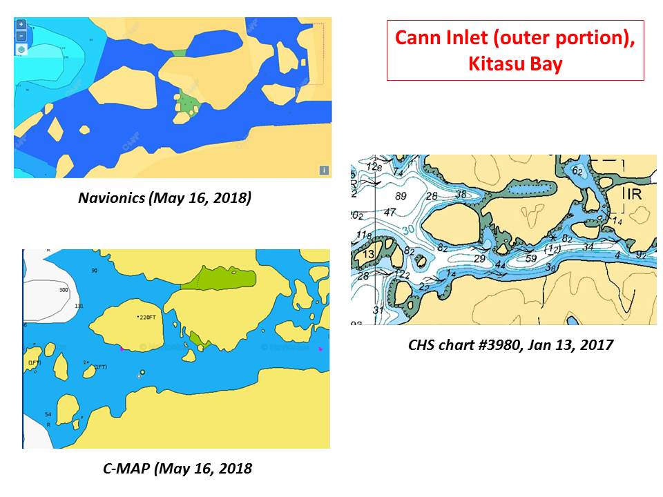
Cann Inlet is close by (to the east of) Coward's Cove. The outer half of this inlet is well-surveyed in the 2017 CHS chart (the inner half remains "unsurveyed"). As with Coward's Cove, neither C-MAP nor Navionics show the detailed depth and hazards information provided by the CHS chart (indeed, they show essentially
no information).
 |
| More than a year after chart update available, Navionics and C-MAP charts still missing CHS Cann Inlet data |
C-MAP and Navionics charts covering the British Columbia coast are much less expensive that the equivalent set of CHS raster charts. (Indeed, Navionics and C-MAP charts for iPad and Android are inexpensive.) However, as the above demonstrates, these commercial charts do not necessarily keep up-to-date with CHS charts and surveys.
Our boat Pelagia's safety (and ours) is worth paying the higher price of official CHS charts.
In practice, we use the C-MAP charts on our cockpit chartplotter, but
double check these with updated CHS raster charts (which we often run simultaneously on Android at the helm).
*
Navionics (and to a lesser extent, C-MAP) offers chart views with additional depth information ("Sonar Charts"). In many cases, this increased "detail" appears to simply be an interpolation between surveyed depths (i.e., not real depth data). In places with sparse depth surveys, these interpolations are at best, guesses. In other cases, the increased detail may derive from community-derived (crowd-sourced) depth information. It is not made clear where the data comes from. In the latter case, there is no accounting for variables such as tide level, location of depth transducer on hull, accuracy/inaccuracy of transducer calibration, or errors due to sea bed (e.g., weed or kelp giving erroneous readings). The internet has numerous examples of problems (for example: 1, 2, 3, 4) with these crowd-sourced Navionics Sonar Charts. I wouldn't touch them.