This post provides further information for cruisers considering/planning a cruise to Pacific Mexico. Preceding posts include: (i) Charts, Cruising Guides & Weather Sources for Mexico, (ii) C-MAP vs SEMAR charts, (iii) CM-93 vector charts, and (iv) using Google Earth and GE2KAP to create GPS-accurate GE image "charts".
UPDATE March 2022: See new post on "Best chartplotter and chart source for Mexico: OpenCPN & O-CHARTS"
UPDATE 2021(Jan): For the locations noted below, both C-MAP and Navionics now show the same updated details. However, the newer more-detailed SEMAR raster chart (but not included in the SEMAR vector set) for "the islands" in Bahia de la Paz (THE main cruising area for boats out of La Paz, BCS) is missing from CMAP and incorrect for Navionics (I prefer "no data" to "wrong data"!)
The differences noted below in this 2016 post show the kind of differences that can exist (the ones below are now corrected). The only way to know if a commercial chart is updated is to compare to up-to-date SEMAR charts.
2016 post:
In a number of preceding posts, we've noted that in some places in Mexico, "up-to-date" Navionics charts lack the updated detail found in "up-to-date" C-MAP charts.
Increased detail in a chart does not guarantee the chart is more "accurate"; however, it likely indicates the chart has added in updates from the official Mexican nautical chart supplier, SEMAR.
Below are several examples in the Sea of Cortez (and south to San Blas) where we've found Navionics charts lacking in detail compared to C-MAP charts. Readers may find the opposite in other areas (although we have not seen this).
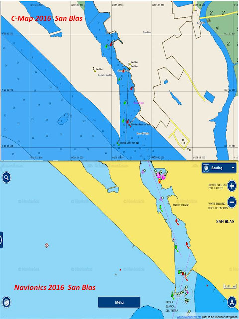
In the examples below, the C-MAP image is always on top and the Navionics on the bottom. Each is zoomed so that the maximum detail available is shown.
La Palmita anchorage (south of B. Conception):
Loreto:
Altata:
San Blas/B. Matanchen:
Cruisers should use multiple sources of information rather than relying solely on only one commercial chart source (e.g., Navionics or C-MAP). Given the relatively low expense of Navionics and C-MAP electronic charts, especially on IOS and Android platforms, it makes sense to use both (as well as charts from CM93, GE-image, Blue Latitude Press, and, if you have them, SEMAR).
Importantly, as we have seen up in BC waters, commercial charts such as Navionics and C-Map are often not up-to-date with official chart sources (and may take months to over a year to include an update).
Both Navionics and Jeppesen/C-MAP provide methods to report a "Cartography Discrepancy". However, these require some work to submit, and for large areas where a chart does not include the most up-to-date cartography provided by the official cartography office (in this case, SEMAR), it would seem the responsibility of the electronic chart provider to keep their charts for sale to the public up-to-date!


Very helpful in decision making. Thanks!
ReplyDeleteGlad to help.
DeleteIn this post, I didn't mean to play favourites, BUT.... It seemed so many were talking about Navionics and I thought people should see some issues. Having both C-Map and Navionics has been interesting. (Not really an issue for USA and Canada charting -- they both seem equally accurate, though each has its unique display features/methods.)
For charts of the west coast of Mexico, I highly recommend you also get the Blue Latitude Press charts (very accurate chartlets from Shawn & Heather's great cruising guides). Covers specific anchorages, not everything. Available from XTraverse.
(Blue Latitude also provides, at a miniscule cost, electronic versions of all their waypoints. VERY worth it.)
cheers, David
I am not sure if my previous post made it to the site so I am re-posting again.
ReplyDeleteI am planning to sail the baja peninsula and I am looking for some charts specifically CM93 charts of Mexico. Links on the web appear to be broken and was wondering if you would be able to share your CM93 charts. Thanks beforehand.
Just checked Navionics:
ReplyDeleteAltata, Loreto and San Blas/Matanchen are now UP-TO-DATE
ALSO: FINALLY, there is a (new)DETAILED Mexican SEMAR chart (Jan 2018; Corrected October 2018) covering "The Islands" of Bahia La Paz (Espiritu Santo, etc).
MX 25110 BAHÍA LA PAZ, B.C.S. 1:20,000 1ra.Ed: ENERO 2018 / CORR. A. M. OCTUBRE 2018
PROOF that Mexico DOES issue new, detailed charts!
Navionics reflects this new chart. Oddly, C-MAP does not (yet).