Monday, 31 July 2017

Mt. Llanover trail partially destroyed by logging (Roscoe Bay, Desolation Sound)

After the loggers have left....
In June, we spent 4 nights in Roscoe Bay, one of our favourite anchorages (see our previous blog post). One reason we like Roscoe Bay is the hike up to Mt. Llanover. This year we got a shock.

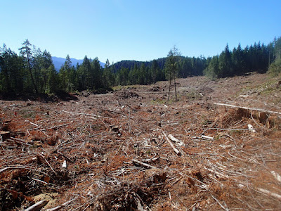
Logging in 2016-2017 has significantly impacted the trail up Mt. Llanover (not to mention other impacts). About 30 minutes up from Roscoe Bay trailhead, logging has completely destroyed the trail (for a short section). We spent nearly an hour lost trying to find the trail. Making it worse, there was significant deadfall on other parts of the the trail, likely because, due to the logging, no one was hiking the trail and keeping it clear. In the past, we typically go up and down in 3-3.5 hours (including a short lunch at top); this year, it took us over 5 hours (with many cuts and scratches on our legs)!

The trail used to pass through this area... (no, the road does not head in the trail direction)

We did eventually find the trail again above the logging (and the many chopped-down logs on the edge across the trail) and made it to the top of Mt. Llanover. The views were still great.

2017 view from top of Mt. Llanover: now a lot more work to reach

Hopefully, over time, local hikers will restore the damaged sections of the trail. We understand that the forest industry in an important part of B.C.'s economy. This blog is not a rant against logging. However, it would have been so easy (and cost little) for the logging company to have assigned a person with a chainsaw to clear the trail and ensure its continued availability. (Indeed, being community minded, perhaps that person could have done some extra clearing/cleaning up of the trail beyond that they destroyed....) Doing so would certainly help relations between tourism (including boaters, hikers and kayakers) and logging industries.

Saturday, 29 July 2017

To Cape Caution and back

Fog outside of Murray Labyrinth

After leaving Alert Bay, we decided to spend some time on the mainland side towards Cape Caution. Hoping for a sail, we motored past Pulteney Point and headed towards Blunden Harbour. We did indeed get a short and slow sail in (1.5 hours at 3-5 knots), but as usual (for us this Summer), the winds died. Arrival at Blunden Harbour was easy, with lots of space (as has been typical for locations west of Johnstone Strait this Summer). We decided to spend two nights.

While in Blunden, we had a visit with Stan and Pat (SV Alcheringa), who had indicated on the evening HAM net (West Coast Boaters' Net) they were coming down from Skull Cove (Cape Caution area) to say "Hi" to us. We had an enjoyable drink with them on their boat, then we all came back to Pelagia for dinner. Also, while in Blunden, David put out the crab trap. Much to our surprise, we caught more crabs than needed -- we kept 1 Dungenous and 3 Rock Crabs. Michelle made some great crabcakes and dip later.

After two nights in Blunden, we decided to head up to the Cape Caution area. We navigated the tricky entrance into Murray Labyrinth (well, tricky for us, as it was our first time here). This is a fairly small anchorage in the midst of a labyrinth of small and medium-sized islands (hence its name) at the end of Schooner Channel, only 10 or so nautical miles from Cape Caution. It is a wild and remarkably beautiful place (and will almost certainly win the "most beautiful anchorage" award for our cruise this Summer). We stayed 3 nights at Murray Labyrinth, and would have stayed more if the weather forecast stayed stable. 

Wonderful kayaking around Murray Labyrinth
Weather was forecast to turn to strong (possibly gale force)southerly/southeasterly winds. Being near Cape Caution and Queen Charlotte Sound, Murray Labyrinth would be sure to get some strong winds (even though the anchorage has decent protection). We had, by now, decided we were not going North of Cape Caution this Summer (too much rain etc up North this Summer, and the extra time we spent in the Broughtons both contributed to our decision to stay South of Caution). With strong southerly winds forecast, we decided to high-tail it down to the docks in Sointula. The following night, we had lots of rain and strong winds at the dock; up at Cape Caution, winds were in the 30-35 knot range. We congratulated ourselves on our good decision.

We provisioned at the Co-Op store in Sointula, and after a couple nights, headed back to the Broughtons, with the intent to hang around until we would get some decent winds for an Eastbound/Southbound trip back down Johnstone Strait (but not too much...). It was still drizzly when we anchored in the cove by Dead Point (a new anchorage to us), but sun the next morning made us decide to hang out for a little kayaking. Next we were going to anchor in Cutter Cove, but the winds forecast for the strait suggested the "right" winds (15-25 kn West/northwest) in two days, so we got going early, caught slack in Chatham Channel (where, to our surprise, we saw a young grizzly), and anchored at Matilpi. We were the only boat, so we had our choice of the very few spots. Our first choice we became unhappy with as winds were funneling directly at us and we neared an underwater rock. None too pleased to have up-anchor, Michelle nevertheless liked our new spot without a breath of wind and lots of space. Happily, this all occurred before dinner (as opposed to later in the evening.

Young grizzly on the beach in Chatham Channel
The next morning, we motored down Havannah Channel and headed out into the strait. At first, we had only 5-10 knots of wind (behind us) and a current against, so we had to motor. By about half way to Port Neville, the wind filled in and the current died down. Soon we had 15-20 knots of wind and even a 2-4 knots current in our favour (at times 26 knots of wind and 5 knots of favourable current). We finally had the great sail we wished for, all the way to Chatham Point. We completed the day anchoring in Chameleon Harbour. (It was also fortunate to be able to sail, as in Matilpi we discovered a tiny leak of antifreeze -- a dribble -- from a damaged hose between the engine and the water heater. Rubber tape temporarily decreased the drip. We will repair when we get to a dock soon.)

Next day, we transited the Yaculta rapids (Dent, Gillard and Yacultas, which were crazy busy and not so pleasant) and headed to Von Donop Inlet (top of Cortes Island), where we are currently anchored.

We are finally back in our "Southern" waters. It is very warm here in Von Donop (~25 degrees C); Water temperatures are up to 21 degrees C; finally, we are swimming off the boat. On the downside, it is very crowded (40+ boats) -- it is what one must expect returning down South.
Friday, 14 July 2017

Alert Bay: Possibly the friendliest town on the BC coast

We didn't plan to spend three nights at the docks at Alert Bay, but there's lots to see and the people are all very, very friendly. It started right off with a very friendly and helpful wharfinger here at the Public Docks (Thanks Steve!). Then, walking the streets, everyone makes a point of saying "Hi", waving etc. We thought Sointula was friendly, but Alert Bay takes a large step further.

The Kwakwaka'wakw First Nation people have been especially welcoming. We've already been to the U'mista Cultural Centre two times on two previous visits (absolutely a "not-to-missed" visit). This time we decided to take in the T'sasala dance performance in the 'Namgis Big House. Normally, visitors do not get to visit the Big House, but they get to do so for the dance performance. The T'sasala group is made up of  Kwakwaka'wakw kids from the very young to teenagers. The performance was both enthralling and educational, and we visitors were made to feel very very welcome. Definitely time well spent and all of us enjoyed it very much. Overall, Alert Bay is probably one of the best places to experience and learn about local First Nation culture and history, and to meet and interact with locals.

T'sasala dance group (Copyright; no commercial use allowed)

T'sasala dance group (Copyright; no commercial use allowed)

We also did a very nice (and not difficult) hike while at Alert Bay: (i) Alert Bay Ecological Gardens (also known as "Gator Gardens), (ii) John Anderson Big Tree Loop, and then (iii) the Gwakawe (North Side) Trail to the Big House. The swamp in the ecological gardens was probably the highlight; the views toward Malcolm Island on the North Side trail were also nice (though not as dramatic as those on the Bere Point trail on Malcolm Island).

The boardwalk in Gator Gardens (Alert Bay Ecological Garden)
 There are many beautiful totem poles around Alert Bay. Some very old and some very new. And always in your face are the antics of the many eagles and huge (and very vocal ravens) around Alert Bay.

All said, Alert Bay is a great place to visit.*


*For boaters: Steve the harbour manager does his best to accommodate visiting boats. IF docks are full, he will arrange rafting, usually to a local's boat who is away and/or not moving. We found the docks to be comfortable and interesting. Note also, there is fairly decent anchoring in the bay between the public docks and the U'mista Centre.  We've found the local grocery store to be not too bad for provisioning (No, not as good as Port Mac). There is a BC Liquor Store and a Vancity Credit Union in the village. There is also a gas station in town (no fuel dock).

Two weeks (so far) in the Broughtons

We've now spent 2 weeks cruising parts of the Broughtons. Anchorages have been uncrowded and weather mostly benign (although never "hot").


Our first night off of Johnston Strait was spent in the inner bay of Pott's Lagoon. We were very concerned upon entering the outer bay to see a very large log dump and logging operation. However, the inner bay was the same as ever, with the usual floathomes. There were only two of us boats anchored. We did get a very friendly visit from four guys from the logging camp, even inviting us to check out their "Hilton" hotel (bunkhouse) and come for breakfast (possibly tongue in cheek). However, although the logging operation was not visible from the inner lagoon, it still could be heard, and given nothing was stopping them, not even Canada Day, we decided to move on the next morning to Crease Island/Goat Island anchorage.

Logging camp/log dump in Pott's Lagoon outer bay (July, 2017)
Crease Island had a few boats anchored, and we had a little trouble with the rocky bottom (there seemed far more kelp the in previous years), but we had a good two days at Crease, including two kayak outings.

Next was our favourite, Sointula (Malcolm Island). One of the best public docks around, Sointula is very laid back and comfortable. It is hard to leave. We got out our folding bikes (not used for a couple of years) and had a good bike ride, and also did a hike on the Mateoja Heritage Trail to Big Lake (which was very small). We did a little food shopping, but selection and cost were issues at the local Co-Op store. After 3 nights in Sointula -- we could have stayed longer-- we decided to head the few miles over to Port McNeil for fuel, groceries and alcohol.

Port McNeil is very convenient for provisioning, and the public docks pretty good (there is also the "North Island Marina" at the fuel dock, which seems more popular with the power boats). However, Port Mac is entirely lacking in any character or beauty (unless you like parking lots...). One night was a lot.

Next day, we headed out across Queen Charlotte Strait to Cullen Harbour for a much-anticipated meeting with our friends David and Gillian on SV Carousel (who had just come down from the Central Coast). Last year we cruised 19+ days with Carousel going arounf the top of Vancouver Island to Kyuquot with them. A calm windless crossing, but happily Cullen Harbour was empty. We spent the next seven nights with Carousel.

SV Pelagia and SV Carousel anchored in Cullen Harbour

We dinghied through the rapids into Booker Lagoon, spying a bear turning over rocks on the shore, and exploring the channels around the islands near Cullen Harbour. Very beautiful -- we might return over the next week. We then went into the Broughtons proper, spending two nights at "East of Eden" Cove on Eden Island (sometimes called "Ladyboot Cove, due to its shape), then a night at Laura Bay. We checked out the Burdwood  Group (beautiful, but not a great anchorage) and then spent another night at Crease Island (this time with no rocky bottom issues). Finally, we decided to visit Alert Bay, where we are now.

Gillian and David (SV Carousel) with bear on beach (Booker Lagoon)
After seven nights cruising together (with dinners together every night), SV Carousel left this morning to head back down Johnston Strait. We are staying on in Alert Bay for a third night.